Information
- Location
- Karaganda Region, Karkaraly District
- Period
- 2000 BCE – 0
- Type
- Сomplex
- Kind
- Archaeological sites
- Authors
- Бейсенов Арман Зияденович
Sources
- Қазақстанның киелі орындарының географиясы: Табиғат, археология, этнография және діни сәулет өнері нысандарының тізілімі / Жалпы редакциясын басқарған ҚР ҰҒА академигі Байтанаев Б.Ә. – Алматы: Ә.Х. Марғұлан атындағы Археология институты, 2017. – 1-шығарылым. – 904 б.
Description
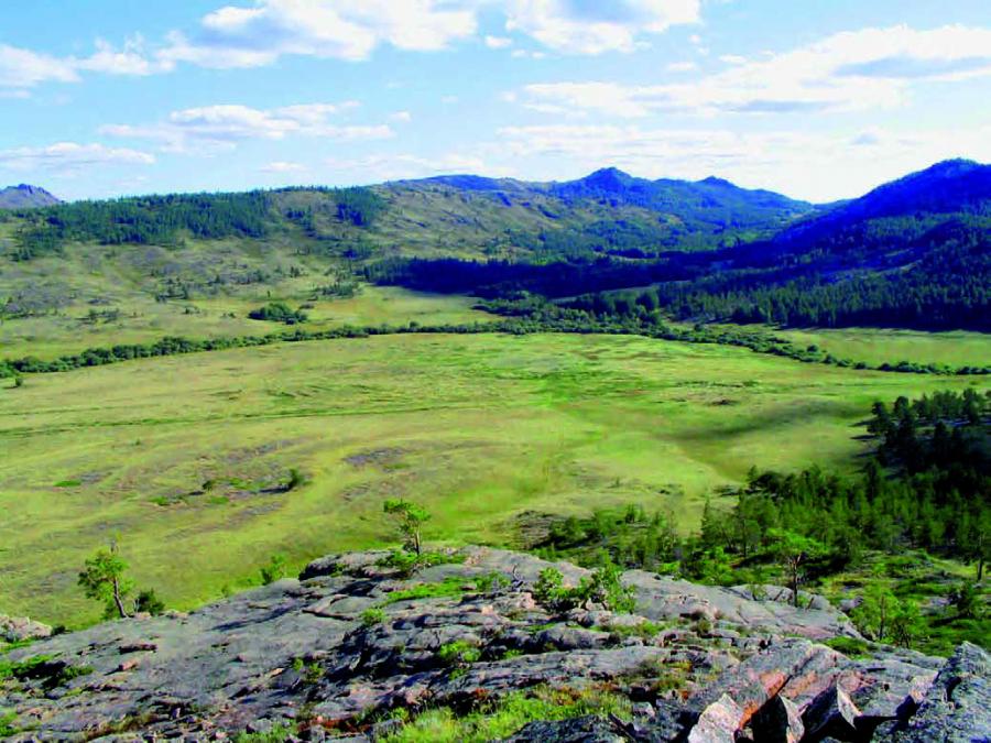
It is an object of archeology and history. Kent mountain massif (absolute height 1 469 m) is located in the eastern part of Karagandy region on the territory of Karkaraly district. A significant part of the mountain range, numerous valleys, gorges and foothill plains are currently located in the lands of the Karkaraly State Nature Park. Of all such natural zones of the Kent Mountains, the Kyzylkenysh Valley is especially important, which means "Red Treasury" in Kazakh. The area is connected with the river of the same name, which is about 25 km long.
A large number of monuments of the Bronze Age, Middle Ages, Kazakh mazars and remnants of the kystau (winter camp), mills, pits to obtain woodspring coal, as well as historical data and folklore data testify to the important role of the Kyzylkenysh Valley in the life of the population for several millennia.
Monuments were examined here by A.Kh. Margulan, who visited this fertile valley for the first time in 1946 - during the first season of the Central Kazakhstan archeological expedition. K.A. Akishev, then student of the Kazakh State University named after S.M. Kirov (nowadays KazNU named after Al-Farabi), participated in the expedition. Then L.F. Semyonov, a prominent local historian, from the Karagandy Regional History and Local Lore Museum, conducted research here. Kyzylkenysh was visited by local lore specialists from Karkaraly - spouses Bogdan and Vera Yasenetsky, who were interested in monuments, Kazakh legends and tales.
Systematic archaeological research has been carried out since the early 1980s. During the entire period of research the priority was the study of monuments of the Bronze Age. A large group of archaeologists participated in the long-term research of the Kyzylkenysh Valley monuments: V.V. Evdokimov, S.U. Zhauimbayev, V.V. Varfolomeyev, I.V. Rudkovsky, V.G. Loman, E.R. Usmanova, V.A. Novozhenov, I.A. Kukushkin, J.E. Smailov, A.Z. Beisenov, M.V. Bedelbayeva and others.
According to materials from such monuments as Akimbek settlement and burial ground, Enbeksuigish burial ground, Kyzyltas settlement, Kyzylkenysh valley was well inhabited in the Andronov epoch, in the beginning of the II millennium BC, although the first inhabitants here were the Neolithic-Eneolithic tribes. A special increase in the population, a sharp rise in socio-economic life is observed for the late Bronze Age, when by the middle of the II millennium BC the Begazy-Dandybay culture of Saryarka flourished.
There are much more monuments of this period, among them the settlement of Big Kent, which is located on the area of 30 hectares at the confluence of the Alat creek into the Kyzylkenish river, deservedly occupies a special place. It is the largest settlement of the Bronze Age in Kazakhstan. Big Kent was a significant place for its time in the rank of a nascent city. Experts define its status as a proto-City. Archaeological research made it possible to establish that the remains of 130 buildings, which were dwelling houses, outbuildings and various workshops, have been preserved in Big Kent Square. In the central part of the settlement there was a large public building, the remains of which were called "Big Fence" by archaeologists. As it is believed, here could be held meetings of the ancient inhabitants, as well as ceremonial processes. In the course of excavations of the settlement a huge number of samples of ceramic tableware, more than 100 bronze objects, numerous highly artistic and beautiful carved bone products, stone and bone tools were found.
The settlement of Dongal has become an eponymous monument for the selection of an entire layer corresponding to the end of the Bronze Age. The materials of the Dongal stage demonstrate the peculiarities of the transition from the Bronze Age to the Early Iron Age. The term "Dongal ceramics" (ceramics of the Dongal type) is introduced into the archaeological nomenclature. Modern developments have made it possible to establish that a ceramic complex of settlements of the Saka era is formed on the basis of Dongal ceramics.
Enbseksuigish, the mausoleum of Begazy-Dandybay culture is located at the entrance to the gorge, on the territory of the burial ground of the same name. Before the excavations the object was a stone barrow. In the course of excavations, a large sub-square fence made of large slabs was cleared. The size of the outer row of walls is 9×8.5 m, the inner row is 5.9×5.6 m. The masonry consists of 4 to 10 rows of slabs up to 0.8 m high. In the inner space of the building there was a sub-square box of 3×2.7 m, up to 1.5 m high, which was a burial structure. The space between the walls and the box was densely wrapped in stones and covered with earth. The burial chamber was looted. This structure is one of the stone mausoleums of the Begazy nobility. Scientists believe that the ruler of the Kyzylkenysh Valley, a powerful leader, was buried here, whose power extended to the entire district, the economic center of which was the proto-City of Big Kent.
Materials of research of the settlement of Big Kent, located in the depth of the gorge, and numerous other monuments allowed archaeologists to study the life and life of the ancient inhabitants of the valley Kyzylkenysh. High culture, developed social relations were based on a well-coordinated multi-sectoral economy, in which the leading role belonged to highly productive animal husbandry. Favorable conditions of the intermountain valley, well protected in winter from the winds and storms, allowed the ancient inhabitants to create an effective system of life support.
According to V.V. Varfolomeyev, among 10 settlements of the economic structure of the Kyzylkenysh Valley the Kent settlement dominated as a center, the rest, as a rule, were small villages in its district. Livestock breeding was of a semi-nomadic, outrun cattle breeding type. In summer, shepherds used to go to the banks of nearby rivers, to the open spaces where the cattle were fattening before the winter. Metallurgists and metalworkers lived here. The remains of the iron-rolling furnaces in the Alat section of the Big Kent show that the Kent masters learned the technology of iron in the late Bronze Age. Pottery, bone processing and stone-cutting were developed. Kent carved bone was oriented to the demand from the rich top, so it was exchanged. These beautiful patterned products, which also had a cult character, became one of the stable signs of cultural peculiarities of that time, as evidenced by the finds in such large settlements synchronous to Kent as Buguly-1, Myrzhyk, Shortandybulak and others.
The Kyzylkenysh Valley is surrounded by high and stony mountains. Here, pine and juniper grow on the stones, lower at the foot of the hills and along the river - aspen, birch, willow, berry bushes. In other places you can see stone hillocks, as if grown from the ground, or giant ones, with rounded sides of the block, as if specially, by the hands of an unknown Kent giant, placed for unknown purposes. Everything shines and plays red: stones, trees, and bushes dressed in their golden-red clothes in autumn. Kazakhs aptly called this land the "Red Treasury". Love and respect for this land were undoubtedly passed down to the Kazakhs from the grey antiquity. The feeling of beauty of the surrounding nature and understanding of favorable living conditions in this area were intertwined, rather, with the ancient inhabitants of the valley. Granite rocks taking different, sometimes bizarre forms, playing in the sun on a bright day, increasing the continuous rumble and shine of lightning, the noise of water in rainy weather, at night creating mysterious, gloomy images, all the surrounding nature has left its mark on the system of religious and philosophical views of the ancient inhabitants. Sacralization of the Kyzylkenysh Valley took place already in the ancient epoch.
The Kyzylkent palace, which has long been known to the Kazakhs as "Kyz Aulie", according to research data, was built in the XVII century by Oirats, who were in friendly relations with the Kazakhs. In 1820, the head of the Siberian Cossack Corps, the future head of the Omsk region, General Semyon Bronevsky, known in the context of important historical events related to the opening of the Karkaraly external district (Karkaraly duany), conducted the first study of the palace. With the help of local Kazakhs he hired, he carried out small excavations, including clearing the floor of the palace from the rubble. He left the first description of the palace, noting that there were other buildings around it. The palace is mentioned in the works of A. Levshin, N. I. Krasovsky, its description is available in the works of V. Nikitin, N. Konshin, L. Chermak, D. Baizhumurov, in the materials of the expedition of F. Shcherbina. In 1928 the monument was examined by I. Chekaninsky, who in his article considered the palace as a Lamaist monastery. Archaeologist S.S. Chernikov in his 1960 article also pays attention to this monument. In the course of preparation for the publication of the Archaeological Map of Kazakhstan, the palace was visited by employees of the Central Kazakhstan archeological expedition led by A. Kh. Margulan, which took place in the 1950s. Thus, the monument, known to the Kazakhs under the sole name of "Kyz Aulie", in published works acquired a stable name of the Kyzylkent Palace.
Archaeological excavations of the Kyzylkent Palace were started in 1985 by the "Kazprojectrestoration" Institute (headed by R.B. Ismagilov). Further research was continued by the archeological expedition of KarSU. During the field seasons of 1986-1987 the monument was occupied by the student group "Evrika" (headed by Zh.E. Smayilov, head of the department A.Z. Beisenov, E.M. Smagulov), created on the initiative of professor A.K. Abilev. The palace and three separate structures were completely cleared, and 10 small stone graves were opened at the burial ground located near these structures. Zh.E. Smailov and A.Z. Beisenov conducted a special study, which focused on the history of the Oirat Khanate and the Kazakh-Oirat relations of the middle of the XVII century. It was a cross-shaped stone structure with an upper floor supported by wooden columns. The walls remained at a height of 1.2-2.7 m with a thickness of 0.8-1 m. There is a small water reservoir and three small residential and household buildings around it. The results of the study were reflected in a number of publications. Archaeological excavations have shown the presence of a very insignificant cultural layer. Among the few finds there are fragments of wooden openworked solids painted red and yellow, fragments of ironware, two round lead bullets, three fragments of easel ceramics, beads, mica fragments, etc. The palace was inhabited in a very short period of time, but apparently it was never lived in.
All excavated graves around the palace are burials of the Kazakhs, for whom the ruins of the buildings were a holy place associated with the Kalmyk girl who gave birth to a son from the Kazakh Batyr. For a long time Kazakhs made pilgrimages to the Palace of the Holy Virgin (Kyz Aulie), around the building rites and rituals were conducted within the framework of the norms of Islam with the reading of the Koran and the sacrifice of a sheep (kudaiyga koy atap soiyp, kuran okidy, alystan kelgender sol zherde tuneidi).
It was believed that the Holy Virgin patronized young women and brides, and visiting this place would bring good luck, happiness and well-being to girls preparing for a new life, as well as young mothers (informants: pensioners Gabdolla Sarsenbayev, born in 1904), Musa Toksanbayev, born in 1900, and Toleutay Khasenov, born in 1907; foresters Zhakan Orazalinov, born in 1935, and Lyazzat Gabdullin, born in 1949; field notes by A.Z. Beisenov, 1982-1984, 1986-1987). Information from informants confirmed the words of General Bronevsky, who in his work in 1830 specifically noted that Kazakhs "worship" this place and that he saw there "different victims of their scraps of matter, bones and poles with horsehairs". When Bronevsky ordered the Kazakhs to clear the floor of the palace, they were "in unexplained fear".
As a result of the conducted researches in the beginning of 1990s Zh.E. Smailov and A.Z. Beisenov came to a conclusion that the palace as a temple could be built in 1640s by Hoshout knyaz Khundulen-Ubashi (ubushi) - the rival of Batyr Huntaiji and at the same time the supporter of Kazakh rulers. He refused to take part in the "all-oirat" campaign against the Kazakhs, referring to the fact that he was a friend of Zhangir Khan. Later on Khundulen Ubashi left the lands under the control of Batyr and his supporters and, having passed through the Kazakh possessions, moved to the Volga River. It was during his movement to the west that he was able to build a temple, which became a holy place of "Kyz Aulie" for the Kazakhs. The results of this research were published in 1996. A fascinating legend about the noble "Shetirejip" and her son, a brave and mighty hero "Syna", born of a Kazakh batyr, was recorded in 1983, 1986 by G. Sarsenbayev. The same legend was recorded by the expedition of F. Shcherbina at the end of the XIX century from the mouth of Sultan Akbai Zholdy, who lived in the Kent parish, at the wintering "at the spring Kyzylkenysh".
Kazakhs considered the Kyzylkenysh Valley a kind of earthly paradise, based on the natural conditions of this land. For many generations, the happy corner of the Kent Mountains has become the center of prosperity, a territory of good spirits. In the area of Diyrmen burial ground in the beginning of the XX century a mill worked. In the valley Kazakhs sowed wheat, millet and barley. Blacksmiths lived in the valley, with whose activity large pits are connected along the river, where charcoal was burned. The mountain range in the Narbas settlement and burial ground is connected with the legend of the mighty golden eagle. "The Narbas Bird" was his name because of the fact that he seemed to have a big head that was not typical for many of his brothers. There were several versions of the legend of Narbas. According to one of them, this powerful golden eagle, who was able to split a young sheep's bone with his beak (toktynyng zhiligin tumsygymen kak aiyrady), hit his breast on the cliff after the death of his master (informant G. Sarsenbayev, 1983, 1986). This stone was named after the golden eagle. According to another variant (informant M. Toksanbayev, 1986), Narbas did not die hitting the stone, but disappeared, hiding his resentment against the people, because they were guilty of the death of the owner (Azhaly kisi kolynan bolgan deydi). But even after many decades, at dawn, people could hear the dumpling of an eagle coming from above, although no one could see the bird itself. After the war it stopped. After Narbas, there were no golden eagles on Kyzylkenysh (Narbastan keyin Kyzylkenyshte burkit atauly bolgan zhok deytin).
Kyzylkenysh has a history, surprisingly embodied in the names of modern archaeological monuments, the materials of which allowed to restore, in turn, its ancient part. Burial grounds and settlements excavated in the Tasirbai tract (the burial ground of the same name), Alat (one-name settlement), Akimbek (settlement and burial ground), Kyshtan (settlement) and many others, tell us the names of the deceased residents.
Tasyrbai Esbai (Tasyrbai Esbaiuly), Kyshtan Zauzan, Akimbek Seilkhan, Akbai Zholdy lived in the Kent parish, in the Kyzylkenysh tract in the second half - end of the XIX century, and information about them was included in the records of the expedition staff of F. Shcherbina, among whom were well aware of the area A. Bokeykhanov, D. Satybaldin, M. Chumbalov and others.
Tasyrbai Esbai is the leader of the village No. 25, the 1st seniority of the Kent parish. He managed four households (families) with four yurts, four dugouts (shym ui), one wooden house (agash ui) and four shoshalas ("kitchen and pantry"). There were 36 horses, 12 cows and 30 sheep. Wintering in the tract "Ala at Olgen" at the water spring - "Alat River". All four hay farms were removed, the number of dugouts was 180. Not far from them stood the winter village of Kyshtan Zauzan, enrolled as "village number 26". These were the households of ordinary people with average income. Slightly different from such families of the auls of sultans, where there were more farms and more people living.
Aul No. 23 of the same seniority was located downstream at the entrance to the gorge. The leader of this village, Sultan Akbai Zholdy, as well as Sultan Akimbek Seilkhan, his close relative, who lived in the neighborhood, are also known by folklore data as literate people, who provided much assistance in the organization of the region. Akbai Zholdy had 17 households in his village, two of which were hired workers. There were arable land for wheat - 10 poods were sown. Hay was mowed by 11 farms, three farms were bought. Famous scientist, geologist A. Mashanov, who was brought up by them for several years, was associated with Akimbek Seilkhan's family (message to A.Z. Mashanov and Zh.E. Smailov, 1989).
The Kyzylkenysh Valley, as in ancient times, was especially appreciated by Kazakhs in winter. As noted by the expedition of F. Shcherbina, the summer camps were located near the gorge, in the open valleys of the Taldy River. Modern archaeological research has allowed scientists to draw a conclusion that ceramics clusters located on the banks of the Taldy River mark the places of summer temporary camps of the late Bronze Age population, leading to distillation and outrun cattle breeding. Judging by these data, the foundations of the traditional economy of the population of the Kyzylkenysh Valley have not changed for a very long time.
In the past, a terrible disaster for Kazakh households was the zhut. During one zhut, which took place in 1897-1898, 45% of all cattle fell in Karkaraly district. In such years, against the backdrop of a terrible disaster, the importance of especially favorable areas, which bypassed the zhut, increased. One such place was the Kyzylkenysh Valley. The following information about this area was compiled by the staff of the Shcherbina expedition: "...the best hayfields are combined with excellent winter pastures. As they say, there was not a single zhut in Kyzylkenysh. Thanks to this, Kyzylkenysh attracts the attention of neighbors whenever the zhut comes. In 1898, many people were rescued here. In winter, many "tenants from different parishes" also come to Kyzylkenysh. As for irrigated agriculture, it is noted that the main arable lands were "on the spring of Kyzylkenysh", from where they "carry water". "Three togans (ponds) were also on the Taldy River.
The Kent mountains and the Kyzylkenysh Valley are connected with the name of one of the last khans of the Middle Zhuz Bokei, son of Barak Sultan, as well as with important events that took place in the times of his descendants. As the materials of A. Bokeykhanov, N. Konshin and other researchers show, as well as folklore data, Bokey, who arrived at the invitation of local Kazakh communities in the 1740s as a teenager, laid new foundations for local governance, leaving many descendants. By the arrival of Russian dignitaries on the eve of the opening of the Karkaraly duan in the beginning of the XIX century, local Kazakhs were ruled by an elderly khan Bokey and his son Genghis in 13 parishes that existed before the establishment of the new district administration. According to A. Bokeykhanov, Bokey and his son Genghis, who was also considered by the Kazakhs to be their khan, were buried in the area of "Khan Suyegi" near Botakara.
Available data suggest that Khan Bokey originally lived in the area of Shalkar and Karatobe gorges (Khannyng Karatobesi), apparently in the vicinity of Kyzylkenysh gorge. His son Genghis, having taken from his father "yenshy" (share), has allocated a separate wintering in the tract Kyzylkenysh that has taken place in the middle of the XVIII century. Sultan Akbai Zholdy, written down in materials of expedition of F.Shcherbina of the end of the XIX century, being born from the younger son of Genghis, has inherited, according to the Kazakh custom, this old wintering - "karikystau". Important events unfolded in the 1820s, during the rapid preparation of the Karkaraly duan discovery, around this old wintering of Genghis Bokeykhanov. The wintering was not only located in the extremely convenient valley of Kyzylkenysh, about which the legends were composed, but also was considered a kind of memory of the khan Bokey. It was the basis for the claims of the descendants of Bokey before the new power, and also embodied their own claims of these sultans, who defended their considerable interests and their people. The Russian government in the person of General Bronevsky, very well aware of the conditions and qualities of the area, planned to arrange a new city of Karkaraly in front of the valley Kyzylkenysh, at the entrance to the gorge. For Tursun Chingisov (Zhamantai Khan), the future elder-sultan of the Karkaraly duan, this meant losing not only the Kyzylkenysh valley, but also the "father's karikystau" forever. During the tumultuous debate, Bronevsky had to yield to the energetic and ambitious sultan Tursun Chingisov, who could well have disrupted such an important event as the opening of the district. At his will, his city of Karkaraly was arranged in another place.
The picturesque Kyzylkenysh Valley is now a place of active visiting of numerous tourists, pilgrims. The territory is part of the protected area of the Kent Forestry of the Karkara National Nature Park. D. Orazalinov and B. Gabdullin, who have continued the family tradition of protecting their native nature, are busy in the field of tourism - State Inspector K. Makhambetshina. The sites of the main excavations have been rehabilitated at the initiative of Karagandy Regional Department of Culture.