Information
- Location
- Karaganda Region, Aktogay District
- Period
- 0
- Type
- Сomplex
- Kind
- Archaeological sites
Sources
- Қазақстанның киелі орындарының географиясы: Табиғат, археология, этнография және діни сәулет өнері нысандарының тізілімі / Жалпы редакциясын басқарған ҚР ҰҒА академигі Байтанаев Б.Ә. – Алматы: Ә.Х. Марғұлан атындағы Археология институты, 2017. – 1-шығарылым. – 904 б.
Description
The monument of archeology is located in 40 km to the northwest from the regional center, in 2 km to the west from the village of Korpetai, on the right bank of the river Nurtai (Zhidebai rural area, Aktogai district, Karagandy region).
The name of the monument dates back to the early period of activity of the Central Kazakhstan Archaeological Expedition (CSAE). It is widely believed that such a name was given to the monument by A.Kh. Margulan based on information received from local residents. It proves to be true nowadays, as the people still have such a name - "37 Batyrs", "37 batyr korymy".
Judging by the fragments of stories by the elders of the passed generation, the Kazakh understanding of the essence of the monument, as it seems, has not gone far from the truth. As they say, here are buried the ancient knight and his 37 nukers-batyrs, who stood in front of hordes of enemies in the valley of Korpetay. Stone menhirs are the silent and severe guards who guard the peace and eternal sleep of the ancient Batyrs, frozen forever. At the same time, it was once said that the stones moved at night, but by dawn they took their place again. It was as if it was seen by people riding horses near the dark silhouettes of the stones at night. The collective farmers who participated in the war explained such stories by the fact that at night the commanders check the posts (askerde bastyktar tuni boiy karauyldardy tekseredi).
Ancient stories, with the exception of short and rare echoes, have gone to oblivion with storytellers, people born in the valleys of Nurtai and Korpetai. The new and radical reorganization of the life of the villagers during the years of state farm construction brought new events and, accordingly, a new understanding. In the course of new researches in the menhirs' area the remains of cloth scraps were found. A survey of the few residents of nearby wintering grounds and villages has shown that the tradition of tying shreds of cloth on these ancient menhirs was preserved until the 1960s.
The monument was discovered by the CSAE in the late 1940s and excavated in 1952. The large mound of the complex was heavily looted and did not give any dating finds, as well as five small structures opened. Brief results of researches are resulted in article M.K. Kadyrbaev (1959), the complex is also mentioned in the book of A. Kh. Margulan with co-authors, dedicated to the architecture of Kazakhstan. Repeated studies were not conducted, although even then attention was paid to the complicated structure of the complex. This, obviously, was connected with the fact that since the end of 1950s planned researches of monuments of the early Iron Age of Central Kazakhstan were transferred to the north, to the area of the Shiderty River coasts, where later numerous mounds of Tasmola culture were discovered. The plan of the complex, shot in the course of researches in 1952 and drawn on millimeter paper, was stored in the personal archive of K.A.Akishev, who in 1996 transferred it to A.Z.Beisenov. In 1997, A.Z. Beisenov conducted a survey of the monument, according to the results of which in 2004-2006 in the Karagandy Regional Department of Culture the issue of the need for security measures at this site was raised.
In 2012-2013, new research was conducted here (head A.Z. Beisenov, head of the detachment A.E. Kasenalin). The main task assigned to the executors was to carry out works on cleaning, improvement of the monument territory, recultivation and restoration of excavated objects. Along with these activities, a new survey of the structure of the complex was carried out. Results of researches at the present stage allow to conclude that the complex "Barrow of 37 warriors" concerns Tasmola culture of the Central Kazakhstan dated now VIII-V centuries BC.
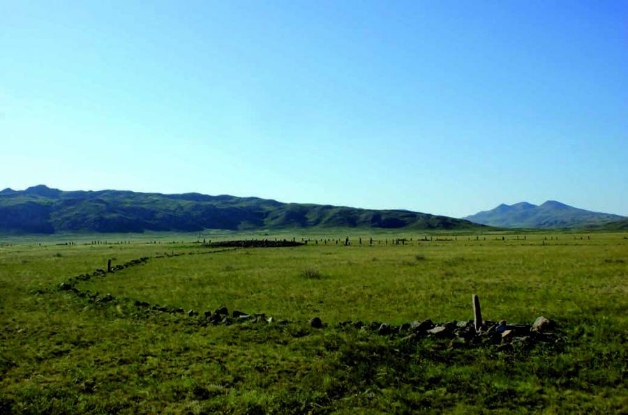
The complex consists of several components: a barrow with "mustache", a system of altars around it and a chain of 37 stone embankments with menhirs. The barrow with the mustache occupies the central part of the complex. To the main barrow from the east is attached a small barrow "satellite", from which two stone ridges, directed to the east, depart. The peculiarities of the planning allow us to conclude that the monument belongs to the type of 2 barrows with "mustache" of Central Kazakhstan (according to the typology of A.Z. Beisenov). The barrow, i.e. the burial mound, is a rounded stone embankment with a diameter of 35 m and a height of 1.3-1.5 m. The stone barrow "satellite" has the following parameters: diameter - 12 m, height - up to 0,8 m. Stone ridges - "mustache" have the initial and end constructions executed in the form of the small, rounded stone-earth embankments. The length of the northern ridge is 140 m, the length of the southern ridge is 120 m, and the distance between the ends of the mustache is 135 m. Throughout the ridge there are menhirs, the average height of which reaches 1 m. The main barrow and satellite barrow are surrounded by a system of altars, which are stone rings up to 1.2 m in diameter. In total 70 altars are fixed. Further, on the northern side of the main barrow, behind the ring altars there is a number of menhirs. They are arranged in groups of 2-3 stones, stretched in one line. On the northern side of each group of menhirs there are arched forms of ritual calculations. The height of the menhirs varies from 1.2 m to 2.1 m. There are a total of 20 menhirs here.
The northern part of the ensemble is occupied by a system of small round-oval stone embankments located along an arc-shaped chain. The average diameter of the objects is 6-8 m, the height is up to 0.3 m. A total of 37 embankments are fixed. Each embankment corresponds to a group of menhirs of 3-6 stones, located on its northern side and stretched in one line. Similar to the menhiric groups near the large barrow, there are also arc-shaped rituals on the northern side of the barrow. The height of the menhirs varies from 1 to 2 m. Perhaps, menhiric groups with calculations indicate that each embankment repeats a large mound in its semantics.
In total, there are 100 menhirs on the complex. But many of them have not survived due to the sampling of stones for construction work in the 1960s and 1970s. Two structures from a chain of 37 embankments were excavated. One of them did not contain a grave pit. Under the second structure, marked as burial mound No. 11, the looted burial of a man in a dromo grave was opened. Dating objects have not survived. The results of the radiocarbon analysis are stacked in the VIII-V centuries BC. According to the definition of paleantropologists, here was buried a man aged 35-45 years.
The central element of the complex "Barrow of 37 soldiers" is the burial structure of the Tasmola culture - a large barrow, built of stone. The current height of the barrow is approximately determined during the recultivation works. Perhaps, the barrow originally had a height of about 3-3.5 m with a diameter of 35 m. All other elements of the ensemble, apparently, were formed in the course of the further repeated actions, which were based on both new burials and memorial celebrations held for a long time. Such labor-intensive and complicated complexes are unlikely to be built in a short time. The natural conditions of the area, including the presence of a wide valley, a river and rocky hills, allowed to carry out ritual activities here at a confluence of a large number of people.