Information
- Location
- Kyzylorda Region, Karmakshy District
- Period
- 300 BCE – 900
- Category
- Historical and cultural monuments of republican significance
- Type
- Сomplex
- Kind
- Archaeological sites
- Authors
- Воякин Дмитрий Алексеевич
Sources
- Қазақстанның киелі орындарының географиясы: Табиғат, археология, этнография және діни сәулет өнері нысандарының тізілімі / Жалпы редакциясын басқарған ҚР ҰҒА академигі Байтанаев Б.Ә. – Алматы: Ә.Х. Марғұлан атындағы Археология институты, 2017. – 1-шығарылым. – 904 б.
Description
The Eastern Aral Sea region has been one of the most important areas of permanent cultural and ethnic contacts between pastoralists of the Great Eurasian Steppe Belt and farmers of the oldest oases in Central Asia since ancient times. The historical tradition has preserved the idea of the Syr Darya, called by ancient authors of the Yaksarts, medieval Turkic sources Yinchu-uguz, by Arab authors of Seyhun, as the border of the two worlds - the northern Turan and southern Iran, pastoralists and farmers, the city and the steppe.
The Eastern Aral Sea region (and, first of all, the northern part of the vast ancient Syr Darya delta) was a kind of "crossroads" of historical routes of movement of peoples, important migration routes, as well as trade roads. There were also places of traditional "wintering" of cattle-breeding and semi-settled tribes. Physico-geographical features of this region provided specific conditions of historical processes of interaction of different tribes and tribal groups representing various cultural and economic types. It was here that the conditions for sustainable coexistence of representatives of different ethnic groups were formed for centuries. All this caused specificity and complexity of the most active ethnogenetic processes taking place here, which allowed the famous archaeologist S.P. Tolstov in the 1940s to identify the Aral Sea region as a territory of particular importance in ethnic history, calling it "Aral ethnogenesis knot".
The sacral nature of the monuments of the Zhetyasar oasis, above all, lies in the symbolism of the elements of a complex and rich ethnic history, which are reflected in the archaeological monuments that the Zhetyasar oasis is rich in. Unusual stability and special conservatism in external archaism are manifested in all aspects of Jetiasar culture: topography and planning of hillforts; construction techniques; principles of fortification, internal residential buildings, funerary structures and rites; ceramics, basic household items and clothing. Also economy and the social organization practically did not vary, as far as it is possible to judge on archaeological finds. The location of Jetiasar hillforts on the Silk Road and historical routes of the pastoral tribes and the related wide trade relations did not affect the appearance of culture, but may have contributed to its conservatism and external archaism. The uniformity of cultural traits provides a unique opportunity to clearly identify foreign cultural elements and to trace the nature, direction and extent of contact types and forms.
The Zhetyasar culture opens pages of ethnic history of Kazakhstan, some historical stages of formation of the Kazakh people, testifying to powerful interaction of two ethnoses - Turkic and so-called "Iranian super-ethnos". The Zhetyasar culture during its existence (the beginning of the I millennium BC - IX century AD) is connected with the names of Saks, Alans, Kanguys, Eftalits, Hionites, Oguz-Pechenese tribes and many others, who played a significant role in the ethnocultural history of virtually all Eurasian peoples. The Zhetyasar archaeological complex in all its diversity represents the pages of the history of the Silk Road, a symbol of dialogue, peaceful coexistence and mutual enrichment.
Long-term archeological research of the monuments of the Zhetyasar oasis allowed to obtain the artifacts confirming the intercivilizational exchange for a long time between different communities located on the Silk Road. Findings from the multi-temporal burials of Chinese monochrome and polychrome silks, polychrome patterned Iranian and Syrian silks testify to the trade links of Zhetiasar culture. An interesting find is a fragment of polychrome cotton, structurally identical to patterned Iranian silks, which may indicate the spread of weaving technologies.
The large number of finds indicates constant and prolonged contacts with steppe tribes. Thus, the study of clothing of Zhetiasars, based mainly on the materials of the burial grounds of Altynasar, allowed to outline a circle of analogies in the Eurasian steppes. Many details of men's and women's clothing of the Zhetiasar culture carriers are found in the materials, first of all, in the Eurasian steppes of the Savromat and Sarmatian times, as well as in some rich tombs of Tilla-Tepe belonging to the Yuechzhian culture. Leather garments of horsemen and felt caps with woolen patterned edging, found in tombs, are the closest to the Pazyryk antiquities of the Altai. Headdresses decorated with gilded leather festoons and toilet bags echo those found in the early Hunnic barrows of Mongolia. These links are also confirmed by the findings of ceramics, Hunnish cauldrons, weapons, horse harness and belt sets, as well as fibulae.
Three polychrome buckles found in the burial ground near the Big Kosasar are known from excavations in Hungary and in the Northern Black Sea region in the IV-V centuries AD. Among the Zhetyasar ceramics there are forms typologically close to the ceramics of Southern Kazakhstan and Tien Shan. Bracelets from the burial grounds of Tompak-Asar and Bedahikasar find analogies among the antiquities of Eastern Europe and Central Asia. Analogies to bracelets with the image of heads of snakes are known in burial grounds of Northern Bactria of the I century BC - II century AD. In the course of excavations of Tompak-Asar, chalcedony brackets for fixing sword sheaths were found. Findings of such brackets have been repeatedly fixed before in Korea and in burials of the Han era, as well as found in the burial complexes of the Sarmatians of the Volga region. Links with other regions are traced back to the finds of bronze mirrors - "Peloponnesian", "Bactrian" and other types that find analogies in the monuments of Savromat-Sarmats of the Volga region and Western Kazakhstan, Scythians of the Northern Black Sea region, Central Asia, Greece and other regions. There are also imported Chinese mirrors. The technology of production of local mirrors is unusual - it is hot forging of high-headed bronzes with hardening. Such mirrors are found in the burial grounds of the Sarmatians of the Volga, Urals and Central Asia. This technology probably developed in Southeast Asia, later spread to the East (China, India, Central Asia, Iran) and is mainly associated with the production of cult items: gongs, mirrors, bracelets, smokers, dulcimer, bowls and kiaf. During the excavations of the ancient hillforts and necropolises of Altynasar, Tompakasar, Bedaikasar, and Big Kosasar, 22 Sassanid and Parthian gems made of chalcedony, carnelian, crystal and almandine were found. Gems could penetrate as a result of trade relations or as a military prey.
An important evidence of the existence of the exchange is the mass discovery of beads of semi-precious stones originating from different regions of Eurasia: amber stones from the Baltic States, coral stones from the Mediterranean region, gagate stones from the Caucasus, probably from India were supplied with carnelian, agate, nephrite, chalcedony and rock crystal, from which beads were also made. Most of the glass beads were made from ash from desert plants in the tradition of the Middle Eastern Glassmaking School. Multi-colored and monochrome beads of Egyptian origin were found, made of stretched sticks, one-time wrapping, sintering of glass pieces. Some of the beads are close to purple Chinese beads by their morphological and technological features. There is technological evidence that part of the beads and glass carved vessels could be made in Byzantium.
Apparently, at the end of the I millennium BC, some groups of tribes of Sargat and Gorokhov cultures moved to the Zhetyasar tract from the Trans-Urals and the Ural region. This is confirmed by ceramics found in burial complexes. It is the influence of these cultures that is associated with the appearance of anthropomorphic bronze figures and zoomorphic rivets on ceramics (images of bears on ceramics) in the Zhetiasar environment.
Thus, the interaction of different cultures, leading to the enrichment of universal values for several centuries, is confirmed by numerous artifacts (Chinese monochrome and polychrome silks, polychrome patterned Iranian and Syrian silks, as well as two-layer cotton fabric; Hun-type cauldrons; Chinese mirrors, as well as "Peloponnesian" and "Bactrian" mirrors that find analogies among the Scythian and Savromat-Sarmatian antiquities of the Volga region, Northern Black Sea region, Central Asia and other places; the technology of production of local mirrors originating from Southeast Asia; amber beads from the Baltic States, glass beads, probably of Egyptian and Byzantine origin, coral beads from the Mediterranean Sea, beads of semi-precious stones of Indian origin, gagate beads, probably of Caucasian origin; Parthian and Sassanian gems; anthropomorphic and zoomorphic images from the Ural region and Trans-Urals; Sarmatian fibulae; ceramics, etc.). The analogies given in the analysis of the finds testify to the extensive links between the Zhetyasar culture. It should be noted that the closest connection was with nomadic tribes of the Eurasian steppe belt.
Judging by the archaeological finds, this region was settled by man in the Neolithic and Bronze Age, but it was especially intensively developed in the I millennium BC and I millennium AD. Written sources rarely mention the areas of the Eastern Aral Sea region, but this did not prevent many scientists from linking the regions with the names of the Saks, Alans, Kanguys, Eftalites, Hionites, Oguz-Pechenese tribes and many others, who played an important role in the ethnocultural history of virtually all Eurasian peoples.
All ecological characteristics of the region are also indicative. Huge open plain spaces in the presence of developed complex river systems provided settlement and ease of movement. The formation of space for such historical-ethnic processes was largely determined by the unusual geographical position of the Eastern Aral Sea region on the Eurasian continent. Practically, it is a wide belt covering a huge territory and connecting the areas of Asian and European steppes.
The alluvial plain adjoining the Aral Sea from the east, almost entirely cut through by the old rivers of the huge ancient Syr Darya delta, is a huge triangle in plan. The latter occupies more than 400 km in latitudinal direction and 200-250 km in the meridional one, with a peak in the east from the corridor between the ridges of Karatau and the Kyzylkum plateau, in the place where the Syr Darya comes out to the Turan lowland.
On the vast territory of the plain there are four systems of ancient Syr Darya channels: Inkardarya, Zhanydarya, Kuvandarya and Prakuvandarya (otherwise - Eskidaryalyk), mainly having a latitude direction. All of them diverge radially from the Syr Darya riverbed south of Kyzylorda.
Abundance of fresh water and warm dry climate made this plain adjoining the eastern shore of the Aral Sea attractive for people who lived here permanently and conducted, at least since the end of the Bronze Age, a complex natural economy. At the same time, natural resources were used to the maximum extent: reedbeds were used as cattle feed, sands surrounding oases were used for sheep and camels grazing, flood river washes were used to irrigate fields, lakes and rivers were used for fishing.
Due to its geographical position, the most important migration routes and trade roads in the region, as well as inter-ethnic and intercultural contact zones in the I millennium BC and in the I millennium AD, passed to the north of the Zhanydarya riverbed, in the basin of the ancient northern Syr Darya channels - Kuvandarya and Prakuvandarya (Eskidaryalyk), where during the period under consideration the Zhetiasar culture developed (from the end of the Bronze Age to VIII-IX centuries AD).
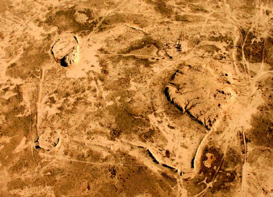
The hillforts of Zhetyasar oasis. "Huge, multilayered, well fortified Djetyasar hillforts were always located in close proximity to the riverbed or any other natural water source (which is also characteristic for this culture) and were surrounded by necropolises, numbering hundreds and thousands of barrows" [Tolstov, 1962, p. 137].
All hillforts are located in groups (or "nests") of 5-7 (up to 10) fortresses in each group. At present, at least 9 groups of simultaneous early settlements are known. As a rule, settlements of such a group gravitated towards a large channel and its branches. At the same time, one of the hillforts (usually central) was distinguished by its large size, while the distance between the fortresses in the group did not exceed 2-8 km. The distance between the individual "nests" was much greater, but the height of even small fortresses with their powerful fortification allowed transmitting light signals from one fortress to another not only within the group, but also from one "nest" to another [Tolstov, 1962, p. 139].
It is in the Zhetyasar tract that it was possible to study and typologize both residential and funerary monuments of the Zhetyasar culture, to identify and trace the dynamics of channels and irrigation structures.
Near each Zhetyasar hillfort there were necropolises containing thousands and tens of thousands of burial mounds. The period of existence of various Zhetyasar hillforts - from two-three centuries to thousand and more years, so the number of burial mounds around the different hillforts was not the same.
Zhetyasar burial grounds were necessarily tied to certain channels, usually located on the banks of the active and blocking the ramparts and beds of the already non-functioning channel or canal. Taking into account that the majority of Zhetyasar hillforts were inhabited for a millennium, some of the channels located in their vicinity during this period were silted and ceased to exist, while others changed their channel; accordingly, the location of different in time burial grounds is connected with certain channels or their groups.
Naturally, the earlier necropolises are connected with the earliest channels. In the process of studying the Zhetyasar burial grounds the researchers had to face the fact that necropolises differ from each other not only chronologically. They managed to fix the facts of existence of simultaneous, but undoubtedly belonging to different ethnic groups of burial grounds, located on different banks of the same channel or even nearby on one bank. All barrows were initially overlapped by earthen embankments, in the absolute majority of cases bordered by a moat. Employees of the Khorezm Archaeological and Ethnographic Expedition excavated 740 barrows containing over a thousand burials. Under the earthen embankments of the barrows brick chambers-vaults were found, as well as underground burials of four types.
Irrigation in the Zhetyasar oasis. Archaeological and topographic surveys combining archaeological ground reconnaissance with interpretation of aerial images and subsequent mapping revealed the continuous evolutionary development of irrigation systems in the Aral Sea region over four and a half thousand years - from their origin in the epoch of primitive times, in antiquity, in the early and late Middle Ages and up to the XIX century.
"Archaeological-topographic study of irrigation structures of Jetyasar tract gives us an opportunity to testify that primitive principles of flood water regulation, known from irrigation of Babish-Mulla and Chirik-Rabat neighborhoods (IV-II cc BC) are being further developed in this region in I millennium AD. Features of this "delta" irrigation are the use of dammed channels, connection of latitudinal channels with canals and application of systems of deepened areas of ducts and dead lakes as pools and reservoirs". [Andrianov, 1969, pp. 202-205].
The natural conditions of the Lower and Middle Syr Darya were characterized by continuous changes in the hydrographic regimes of individual ducts, for example, during the rise of water horizons during the flood that occurred in the warmest season and associated with increased snow and ice melting in the mountains or ice jams in winter ("jams"). During these periods, water from the main channel was widely spilled along the nearest interchannel depressions, old channels and dead lakes. This was noted back in the X century by Masudi, who reports that in Farab the river flooded the space of 30 farrahs, i. e. 200-300 km [Bartold, 1963, p. 234]. With the general western slopes of the Zhetyasar plain, the majority of flood flows rushed westward, so ancient farmers had to spend relatively little effort to direct the water through the aryks to the old ditches and old channels, which turned into reservoir basins. Interestingly, the method of using natural flood spills by farmers in the Lower Syr Darya, apparently, existed until the XVIII-XIX centuries; in particular, this is reported by N. Dingelstedt. Describing the old traditional methods of irrigation in the Kazakh population, he notes that flood waters were gradually brought out through a series of bunded areas and depressions to 60 versts from the main river. The system of reservoirs was probably most widely spread in the late life of the Zhetyasar oasis, when the total amount of water supplied to the main channels of the Prakuvandarya (Northern Kuandarya) decreased.
All hillforts of Zhetyasar oasis are monuments of history and culture of the Republic of Kazakhstan, which are in the list of monuments of either national or local importance. In 2012, the monuments of the Zhetyasar oasis were included in the preliminary list of UNESCO World Cultural Heritage sites as a component of the serial transnational nomination of the "Silk Road".