Information
- Location
- Kyzylorda Region, Kazaly District
- Period
- 801 – 1100
- Category
- Historical and cultural monuments of republican significance
- Type
- City
- Kind
- Archaeological sites
- Authors
- Воякин Дмитрий Алексеевич
Sources
- Қазақстанның киелі орындарының географиясы: Табиғат, археология, этнография және діни сәулет өнері нысандарының тізілімі / Жалпы редакциясын басқарған ҚР ҰҒА академигі Байтанаев Б.Ә. – Алматы: Ә.Х. Марғұлан атындағы Археология институты, 2017. – 1-шығарылым. – 904 б.
Description
It is located in the Eastern Aral Sea region, 5 km south-west of the left bank of the Syr Darya River, 0.5 km south of the village of Urkendeu (Kazalinsk district, Kyzylorda region).
"Yangikent", "Zhankent", "Jankent", "Shekhrkent", "Al-Qar'yat al-Hadisa", "al-Madina al-Jadid", "Dhikh-i-nau", "New City" - that is how the famous in the history capital of Oghuz jabgu (yabgu) was called in different languages and dialects. The famous Arab historian of XI century al-Idrisi called this city "New Guzia". Ibn Haukal, an Arab geographer and traveler of the X century from Baghdad, cites interesting information about Zhankent, called the "new settlement". In his historical and geographical work he directly points out that the "new settlement" is the capital of the Oghuz state. Zhankent, according to him, was the largest settlement in the lower reaches of the Syr Darya. It was not only the capital, but also the winter residence of the Oguz king.
The choice of New Guzia as the political center of the Oguz power was conditioned by many circumstances. The most important of them was the advantageous geographical location of Zhankent at the junction with large agricultural oases of Central Asia. New Guzia served as a corridor connecting the Oguz steppes with Khorezm, Maverannahr and Khorasan. The Syr Darya cities of the Oghuz yabgu were important points of land and river trade. Ibn Khaukal testifies that ships loaded with grain and bread were sailing along the Syr Darya River to the "new village". Zhankent was located on an important caravan route that led through the Kimak steppes to the valleys of Sarysu, Kengir, Ishim and Nura. The capital of the Oghuz yabgu occupied a strategically important position in the region, which has long been a zone of constant contact between nomads of the steppe and Central Asian agricultural oases, a kind of "crossroads" of migration and trade routes. For a long time, the conditions for sustainable coexistence of different ethnic groups were being formed here. Zhankent is a reflection of an important stage in the history of medieval Kazakhstan, closely connected with the origins of Kazakh statehood, ethnogenesis and culture of Kazakhs.
The ancient Turkic tribes of the Oguzes (Guzes), who, as the Arabic-language historical-geographical works testify, created the state at the end of the IX-X century, played an important role not only in the history of medieval Kazakhstan, but also in the history and ethnogenesis of such peoples as Turkmens, Azeris, Turks, Crimean Tatars, Gagauzes, and many others. The actual data contained in the works of Ibn al-Fakih, allow us to conclude that during this period Oguzes had their own statehood and were considered one of the powerful tribes in the Central Asian expanses. In works of XIV century Rashid ad-Din "Collection of annals" and Juweini "History of the world conqueror", there is information about the conquest of Zhankent by Mongolian troops under the leadership of Zhoshy, who conquered the city and assigned (his) ruler there. In the historical memory of the people there are evidences about the attempts of Kazakh khans of Junior Zhuz Abylkhaiyr and Aryngazy to restore the city, which once again confirms the status of Zhankent as an important geopolitical center.
The uniqueness of the hillfort was noted in the XIX century by the famous art historian V.V. Stasov, who put local archeological monuments in one row with the ancient ones and noted: "...Why should the old city near Jankent not be our Pompeii". An important historical object of this monument was considered to be the military, based in the forts on the Syr Darya. They took measures to preserve the ancient hillfort, forbade to destroy old buildings, to disassemble them into bricks. The same V.V.Stasov wrote about it: "Military people, who usually don't care about antiquity, ... now ... are interested in ruins, think about their importance for science, detach the sentries to guard them, try to save them from any harm. Isn't this the most beautiful news we have?"
The history of archeological study of the Aral Sea region and South Kazakhstan began in the second half of the XIX century after their conquest and accession to Russia. In 1867 the famous orientalist P.I. Lerh made a trip here by the order of the Russian Archaeological Commission. He examined and described the remains of the medieval towns of Zhankent, Sauran, Syganak and carried out small excavations in Zhankent. In 1867-1868, and then in 1869-1870 in Southern Kazakhstan visited the famous Russian painter-batalist V.V. Vereshchagin. He also undertook excavations of Zhankent and collected a collection of ceramics. Bright descriptions of the antiquities of the new unknown land, published by him and other scholars and travelers, aroused interest in the history and art of Turkestan in Russian society.
The next stage of the research of antiquities of the Syr Darya Valley is connected with the works of the members of the Turkestan group of amateurs of archeology, created with the scientific support of V.V. Bartold in 1895 in Tashkent. It brought together intellectuals, military personnel, officials and people who were engaged in the archeology of Turkestan to the best of their ability and interest. In the post-war period, the Khorezm Archaeological and Ethnographic Expedition of the USSR Academy of Sciences, headed by Professor S.P. Tolstov, was conducting research in the Aral Sea region. Constant archeological work on the site began in 2005 by the staff of A. Kh. Margulan Institute of Archaeology and the Kyzylorda State University named after Korkyt ata together with the Miklukho-Maklai Institute of Ethnology and Anthropology of the Academy of Sciences of the Russian Federation.
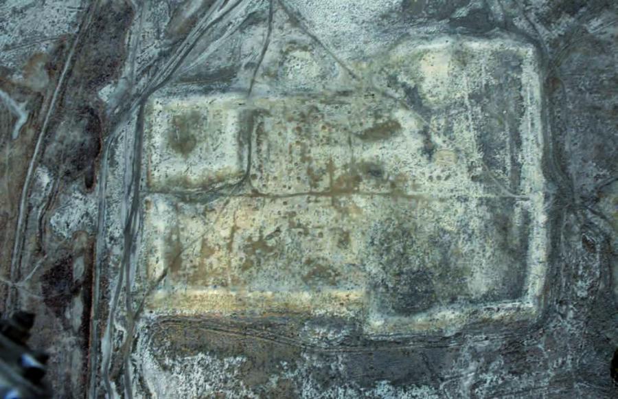
The walls of Zhankent are erected on a flat lowland plain, bounded in the north and north-east by the Syr Darya, in the west by the Aral Sea and in the south by the sands of Kyzylkum. The size of the hillfort along the NW-SE line is 483 m, and along the NE-SW line 333 m. The total area of the hillfort is 159 thousand m2. The hillfort has a T-shaped form - a rectangle with the expansion of the eastern part. The inner space of the medieval city is fenced with powerful fortress walls with towers. In the northwest corner of the aprisot of the outer walls of Zhankent there is a square citadel, separated from Shakhristan by the walls. From the north-east to the wall of Shakhristan adjoins the trapezoidal shape of the entrance ramp.
The citadel is a square of fortress walls measuring 100×100 m. The walls rise 7-8 m above the surrounding area, and 3-4 m above the average level of the hillfort. The inner part of the citadel is densely built in the form of large houses-arrays (blocks), divided by the street network. Shahristan of the hillfort from west to east is divided by the main street running parallel to the outer walls. From the street at right angles leave the alleys, dividing the hillfort into large houses-quarters, quite clearly decoded by air photos. The entrance gate was located on the western and eastern sides. Unstrengthened rabad of Zhankent is located to the north of the Shakhristan of the hillfort. Cultural layers of rabad are strongly dispersed and reduced under the influence of natural erosion processes.
Zhankent is a monument to the history of the state importance. In 2012, it was included in the UNESCO World Cultural Heritage Tentative List as a component of the serial transnational "Silk Road" nomination.