Information
- Location
- Kyzylorda Region, Karmakshy District
- Period
- 500 BCE – 101 BCE
- Category
- Historical and cultural monuments of republican significance
- Type
- City
- Kind
- Archaeological sites
Sources
- Қазақстанның киелі орындарының географиясы: Табиғат, археология, этнография және діни сәулет өнері нысандарының тізілімі / Жалпы редакциясын басқарған ҚР ҰҒА академигі Байтанаев Б.Ә. – Алматы: Ә.Х. Марғұлан атындағы Археология институты, 2017. – 1-шығарылым. – 904 б.
Description
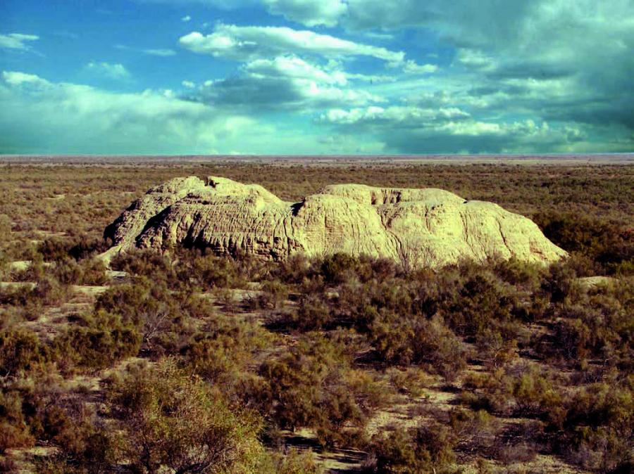
Located on the left bank of the currently dry riverbed of the Zhanadarya River, 300 km south-west of the city of Kyzylorda, 99 km south-south-west of the village of Zhana kala. It dates back to the V-I centuries BC. Secondary hillfort was developed in the IX-XII centuries AD.
The lower reaches of the Syr Darya are the territory saturated with archeological monuments, where physical and geographical peculiarities contributed to the establishment of peculiar contacts between nomadic and sedentary peoples of the Central Asian-Kazakhstani region, which was part of a huge historical and cultural region - the Saka-Massagetian world. The hydrographic situation of the riverside lands was primarily determined by the state of the Syr Darya delta and its relationship to the Aral Sea. Ancient tribes inhabiting the region, known by written sources under the general name of saka-massagets, were an intermediate buffer territory between the southern agricultural oases of early urban culture and the boundless world of mobile nomadic pastoralists in Eurasia.
Historical data on the population of the Syr Darya banks are contained in the works of ancient historians. They distinguish four tribes in the region: Apasiak, Tohar, Augas, Sakarawak. Chirik Rabat is a trade center on the way of the ancient Silk Road with developed crafts and agriculture. In the XIV century AD due to the drying up of the tributaries of the Syr Darya River: Zhanadarya, Kuvandarya and Incardarya - was abandoned by the inhabitants. Archaeological materials allow us to identify three stages of human development in the lower reaches of the Syr Darya in ancient times. The first stage was preurban ( X - end of V centuries BC), i.e. the time of existence of cattle-breeding culture of the Saka world; the second period was the initial stage of urbanization (V-IV - I centuries BC); the third stage was the developed urbanization (I-VI centuries AD) and formation of urban culture.
The Chirikrabat culture was formed no later than the end of the V - beginning of the IV centuries BC in the ancient delta of the Syr Darya. Its carriers were descendants of the Central Asian Scythians - "Saks". Archaeological materials clearly show continuity not only in material culture, but also in funeral rites and rituals with the population of the Late Bronze Age of the Syr Darya lower reaches. The most developed part of the Chirikrabat area is characterized by the oasis concentration of settlements, some of which have a fortified character. The urban centre of Chirik Rabat stands out from them.
The sacral significance of Chirik Rabat hillfort lies in the fact that at an early stage of its existence it was a cult center and was used as a burial place of nobility and tribal leaders who inhabited the surrounding settlements. Chirik Rabat in ancient times was of great strategic importance, as it was on a busy path connecting the deltas of the Amu Darya and Syr Darya, being an outpost of the southern border of the country of Saks-Apasiaks. Obviously, this explains the strengthening of its multi-row defences. It should be noted that the hillfort was settled down several times. The oldest part of it is the northern, higher part of the hill with an area of 40 hectares, where there are six large mounds and five rounded and square in terms of structures made of mud brick (IV-II centuries BC). The oldest fortress was surrounded by a double belt of fortifications. As it was possible to establish researches of 2004, the space between barrows within fortress walls has been occupied by rectangular and oval in the plan of constructions - the territory of the most ancient fortress has been occupied by burial ground.
Funerary structures of various types have been identified: buried underground burials, ground mausoleums, burials in bottoms and simple pits. Besides, on the territory of the most ancient fortress the monumental construction constructed of mud brick which with the big share of probability was a temple is investigated. Fragments of a large anthropomorphic sculpture were found in one of the rooms. Nowadays, barrows with large earthen embankments (type of catacombs) are well visually fixed on the surface of the barrows, including barrows at the Chirik Rabat hillfort, the Akkyr hills and near Sengir-Tam, as well as near the medieval Beshtam hillfort. The second group of funerary monuments of Chirikrabat culture are land-based mausoleums. They are divided into two types: square and round in plan. The third, newly discovered, type of burial structures are burial pits. They represent a complex burial structure of the type of burial vault. All of them are located in the northern part of the hillfort of Chirik Rabat, being a compact group inside the third defensive wall.
On the square of the hillfort traces of several different fortification belts were found. The largest area (42.16 hectares) has the oldest hillfort. It is oval in plan and surrounded by a double belt of fortifications. Synchronous is the subrectangular fortification (12.4 ha) located in the central part of the monument, which can be regarded as a citadel of the ancient hillfort. The southern half of the ancient hillfort (20 ha) is cut off by the wall of the later hillfort, the fortifications of which are the most preserved. At the same time, a late rectangular citadel dating back to the IX-XII centuries was built. This settlement has nothing to do with the main life of the monument.
The hillfort occupies the entire area of a natural hill of 850×600 m, stretching from north to south. It is reinforced by a powerful fortification system. At the base of the hill, a ditch 40 m wide and up to 4.5 m deep, once filled with water, is dug. A powerful external rampart was built from the ditch discharge. Its surviving height is up to 3 m, width at the base is up to 8-10 m. The moat is also surrounded by a rampart from the inside. In addition, the top of the hill is surrounded by a third rampart next to it. Possibly, the synchronous hillfort is made up of residential buildings surrounded by a rectangular defensive rampart, located in the southern gentle part of the hill. During the same period, a new powerful earthen wall up to 4 m high and 4.5 m wide was obviously built on the outer rampart. Inside it there was a shooting gallery up to 1.8 m wide. This wall was reinforced with towers that protruded from the wall at 6 m and were connected from the inside with a shooting gallery. The fortress wall and towers were cut through with arrow-shaped loopholes. Archers could hit the enemy attacking the city through arrow-shaped loopholes. Initially, on the site of the future city was a necropolis with burials of Sak kings.
The first mention of the hillfort is contained in № 10, 31 "Turkestan News", 1904, where the article by I. Belyaev "Poperek Kyzyl-Kumskoy pustyni" ("Across the Kyzyl-Kum Desert"), which describes the ruins of the fortress Chirik Rabat. In the post-war years Chirik Rabat was visually examined by the air reconnaissance unit of the Khorezm archeological-ethnographic expedition headed by S.P. Tolstov. In 1957-1958, 1960-1962 the thorough inspection of the hillfort was carried out by the staff of the Khorezm Archaeological and Ethnographic Expedition. Since 2004 the research has been conducted by the Chirikrabat Archaeological Expedition headed by Zh. Kurmankulov.
Thus, "The ruins of Chirik Rabat - a huge fortress, dating back to the middle of the first millennium BC, surrounded by a system of concentric ramparts and moats, inside which you can see the rectangular layout of a later ancient fortress of the first centuries AD" [Tolstov, 1948]. The materials of the research of the hillfort and the Chirikrabat culture in general demonstrate the high level of culture of the Syrdarya Saks in the IV-II centuries BC. The existence of cities in the lower reaches of the Syr Darya, in the center of the settlement complex, with burials of the local nobility located nearby, developed crafts, architecture, cultural ties with agricultural oases of Central Asia, etc. - evidence of the rich cultural heritage of the Kazakhs in the region.
It is an object of tourism.