Information
- Location
- Түркістан облысы, Turkistan city
- Period
- 501 – 1400
- Type
- City
- Authors
- Смагулов Ерболат Акижанович
Sources
- Қазақстанның киелі орындарының географиясы: Табиғат, археология, этнография және діни сәулет өнері нысандарының тізілімі / Жалпы редакциясын басқарған ҚР ҰҒА академигі Байтанаев Б.Ә. – Алматы: Ә.Х. Марғұлан атындағы Археология институты, 2017. – 1-шығарылым. – 904 б.
Description
The monument is located 40-42 km west of Turkestan, on the western outskirts of Turkestan district (SKR). Karatobe hillfort is a monument of the historical city of Sauran in the period of VI-XIV centuries. Its topography can be described as three space limited by fortress walls, inscribed in each other.
The published "Nasab-nama" of South Kazakhstan's khojas provide data that allow us to assess the role of the city of Sauran in the era of Islamic conquest of the region in the first half of the VIII century. [Muminov, 2003]. It is said about Sauran that before it was known under the name "Sulkhan" and it is reported about it as a place where fierce battles of Muslims with infidels took place, after which a new city was built here (probably, the former one was reconstructed). In particular, it is written that after fierce battles of Muslims in the area of Sayram with the troops of Tubbat-dar, apparently a local Christian ruler (pagan?), and their defeat, he fled to the area of Sauran: "Hadrat Shah 'Abd al-'Aziz-bab became a martyr in this Sayram battle. After that, Tubbat-dar Padishah in the direction of Sulkhan, who is now called Sauran by the Turkic tribes, fled... After that, Ishak-bab, besieging the city of Sulkhan and having spent several days fighting, killed forty thousand unfaithful Christians. Seven thousand Muslims became martyrs. Tubbat-dar Padishahah with two other padishahas from people of Christians has killed. After that Hadrat Ishaq-bab of the land of Turkistan, [as that] Yasi, and Suiri, and Karnak, Ikan and Temir-Kufkan, and Bagistan, and Yetti-Kand, and Altmysh, and Otrar, and Sygnak, and others from the regions and villages, and all people who settled from the sea to the [other] sea, which the Turkic tribes call Tengiz, - all and all turned to Islam". It seems that Sauran became the epicenter of the "war for faith" in this crucial era, its conquest marked the subordination of the entire South Kazakhstan region by Arab-Muslim troops and the conversion of the bulk of the local urban population to Islam.
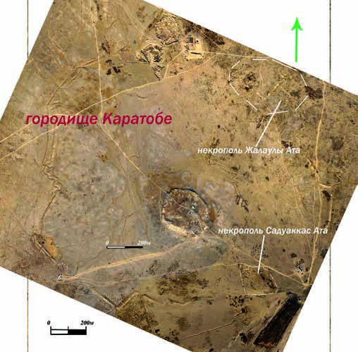
In the light of these data, the origins of South Kazakhstan folklore legends about the many "holy martyrs" associated with such ancient cities as Sairam, Otrar and Sauran, which were strongholds against Muslim expansion in the VIII century, and after the conquest of the new faith and culture that became outposts of the spread of the new faith and culture, become clear. Perhaps the traces of those tragic events are the early layers of two large necropolises, located on the southern and northern sides of the hillfort, but inside the outer ring of the city walls. Apparently, the first gazias found their last refuge here.
These necropolises were practically unexplored archaeologically. Only on the northern necropolis, called by the local population "Zhalauly-Ata Aulie", the ruins of a large raw mausoleum are cleared. Legend has it that he is associated with a certain personality - a former standard-bearer in the troops of Iskhak-baba, who deserved special honors. Around the mausoleum there are a lot of tombs of different times and different types. During the cleaning of the mausoleum near the Saganah the fragments of a stone column with a fragment of Arabic inscriptions were found out vertically excavated. It is possible to assume that stone columns made out grandiose mosque namazgoh which traces are traced there and then. It seems to fit into the outer city wall, so that most of it is inside and part outside the city. If this is the case, it is striking that the size of this namazgoh is grandiose - a rectangle of 200×225 m can be read on the walls.
Another necropolis in the southern part of the hillfort is called "Saduakkas-Ata Aulie". According to legend, this righteous man was one of the first Muslim missionaries, served as akim of Sauran and is known for his outstanding deeds on the way to Allah's service. A long (9 m) massive sagana was allegedly erected over his tomb. And in the past there was a beautiful mausoleum and mosque. Now traces of these buildings are not even visible. There is only one ancient well, as usual, with holy water. Its trunk is partially covered with square bricks. Local folklore equates Saduakkas ata, Shaydai sheikh and Khoja Ahmed with the merits of spreading and strengthening Islam in the Middle Syr Darya.
Around the sagana and well there are many traces of ancient burials. There are burials carried out in the almost destroyed Pakhs' square fences - "Hazira". This urban necropolis, as well as the necropolis of Zhalauly ata, is still a place of active pilgrimage and worship of both the population of local villages and pilgrims coming from far away.
Here we have a rare for Kazakhstan kind of ancient urban necropolises, connected with the persons of early Islamic epoch. Therefore, we can assume a lot of burials of the first fighters for the faith on the necropolises of ancient Sauran, which are sacred for any Muslim of the graves.
The outer walls of Karatobe describe an almost correct circle with a broken contour with a diameter of 1 900-2 000 m and an area of more than 3 km2. In some places the walls have straight sections, sometimes form right angles, in some places they go along the arc. The internal space covered by an external ring of walls, only in some places has dense building, especially in the western half. Arrays of continuous development occupy about a quarter of the entire internal area. The rest of the territory, most likely, did not have a solid construction of capital buildings and could well serve as a place of military field camp, consisting of light mobile buildings. In the center is the city itself with a solid capital construction. This area, apparently, originally had a square shape in terms of shape, oriented corners on the sides of the world with a length of about 550 m and occupied an area of about 0.3 km.
In the centre of this section, the central hill of the hillfort (the ancient citadel) is irregularly oval with a straight southern wall. Its area is 340×280 m, the surface of which rises above the surrounding "square" area by 6-8 m. In the heart of the hill, the microtopography of the hill shows a "floating" rectangle of 130×115 m. In its southeastern part in the form of a massive hill there is the highest point of the whole hillfort.
Archaeological research has shown that the upper boundary of the intensive urban life in Karatoba is the XIII century. The above described topography of the hillfort characterizes the city of the IX-XII centuries, i.e. Samanid and Karakhanid times - the time of the highest heyday of urban life in southern Kazakhstan.