Information
- Location
- Түркістан облысы, Otyrar District
- Period
- 100 BCE – 1800
- Category
- Historical and cultural monuments of republican significance
- Type
- Сomplex
- Kind
- Archaeological sites
- Authors
- Байпақов Карл Молдахметұлы
Sources
- Қазақстанның киелі орындарының географиясы: Табиғат, археология, этнография және діни сәулет өнері нысандарының тізілімі / Жалпы редакциясын басқарған ҚР ҰҒА академигі Байтанаев Б.Ә. – Алматы: Ә.Х. Марғұлан атындағы Археология институты, 2017. – 1-шығарылым. – 904 б.
Description
General information about Otrar and Otrar oasis
The main sources of water supply for the ancient oasis are Arys and Syr Darya. The canals removed from them supplied water to towns and villages and irrigated fields. Only thanks to the abundance of water, arable farming was able to develop here. The Syrdarya Valley, the role and significance of the river in the life of the population of the Otrar oasis and all of Turkestan are described by medieval authors. Ruzbikhan, the author of the XVI century, says the following about the Syr Darya: "This river flows... during 300 tashes and is lost in the sands of Kara-Kurum. All along this stretch, there are plenty of different grasses and reeds of fodder. A lot of ditches were brought out of Darya for irrigation of fields. No other country in the world has such a lot of useful rivers as the Syr Darya; the abundance of dense herbs growing on the banks of the river and wild birds - it is not equal to it; it is very useful for all kinds of animals and wildlife... Along the shores, buried in a variety of colors, live a variety of birds, wild asses, saigas and other animals, grow impassable even for the wind and spirits of the forest of juniper. Syr Darya flows among Turkestan cities, which, like tall trees on the banks of the Darya River, stretch to the sky. The oasis stretches from north to south for 53 km, from west to east for 54 km. Settlements and hillforts form several micro-oases; one of the largest is around Otrar. Its origin dates back to the Early Ages, the first centuries B.C. - the first centuries A.D. The lower layers of the hillforts of Kuyryktobe, Altyntobe, Zhalpaktobe and Kuyik-Mardan, as well as Otrar, belong to this time, they became urban centers in the III-V centuries. In the VII-VIII centuries, the oasis was first part of the Western Turkic, Turkic and Karluk Kaganates. In the second half of the VIII-IX centuries, the oasis, like Southern Kazakhstan, falls under the influence of the Arabs, and then is part of the Samanid state. In the centers of the oasis - the cities of Otrar and Keder - there are minting yards where Turkic tribes of the Kangars minted coins, and in the X century they issued coins on behalf of the Samanids. In the XII-XII centuries Oasis, as well as Ispijab, Yassy, is a part of the Karakhanid state, and in the beginning of the XIII century the power here is seized by khoremshahs. At the beginning of the XIII-XIV centuries, life in most of the hillforts of this micro-oasis fades away, but Otrar rapidly developed in the first half of the XIV-XV centuries and lives until the XVIII century.
The Otrartobe hillfort - the Otrar city
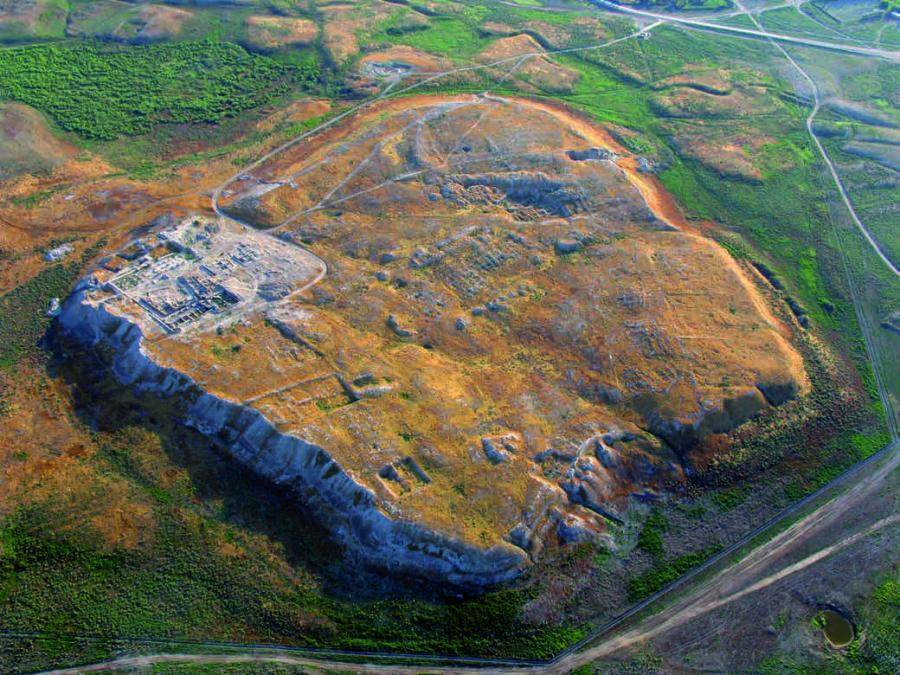
The hillfort of the ancient Otrar is located 10 km west of Timur. In the north-west it is adjacent to the village of Talapty. The safety of the hillfort is satisfactory. An instrumental topographic plan was taken from the hillfort, the monument was photographed from different heights. This allows to give a more detailed description of the ruins. Strartobe is a pentagonal hill plan, oriented by angles on the sides of the world with a slight deviation. Its southern side is 380 m, its south-western side is 145 m, its western side is 400 m, its north-eastern side is 380 m and its eastern side is 350 m. The highest height of the hill from the sole (18 m) in the south-western part; its average height varies from 10 to 15 m.
Excavations have established the presence of nine main chronological horizons, that is, by means of a "large" stratigraphic pits it is possible to pass through the thickness of two thousand years of history: in the first centuries the first buildings of Otrar appeared; the layer of the VII-VIII centuries, containing the remains of monumental buildings, characterizes the early medieval period; rich sets of ceramics and collections of glass found in the layers of the IX-XII centuries, The post-Mongolian and post-Timurian times of the XIII-XV centuries paint a picture of the revival and rise of the city, the heyday of the city falls in the second half of the XV-XVI centuries and, finally, the decline of the city is the layer of the XVIII century. Otrar at this time, as before, was a major sacral center.
The mosque of the XIV - early XV centuries. The historical significance of the mosque is undisputed. It is one of the most interesting constructions of the city of the end of the XIV - beginning of the XV centuries. According to researchers, its construction is connected with the name of Timur, by whose order the mausoleum of Khoja Ahmed Yasawi in Turkestan and the mausoleum of Arslan Bab in the Oasis of Otrar were built on the territory of Kazakhstan.
The mosque is located in the south-eastern part of the central hill. The construction site for the mosque has been carefully reduced. The floor of the mosque was a dense covering. The building (60×22 m) with a long axis stretches along the east-west line. The entrance in the centre of the northern facade is decorated in the form of a portal protruding beyond the wall line with rectangular pylons measuring 2.7 x 1.35 m. The span between the portal pillars is about 6 m. The western pylon remained at a height of 1.7 m, the eastern pylon was almost completely disassembled into bricks. On the corners of the portal were put cylindrical on the base of the minarets with a diameter of 2 m. Inside the minarets there were spiral staircases, which were reached from the inside of the portal through the entrance opening. The first four steps of the stairs on the western side of the portal have been preserved; the front composition of the building includes four through galleries formed by thirty square columns (1.35×1.35) placed in three rows. The opening between the floor pillars was 3.7 m.
In the mihrab wall of the building there is a high threshold doorway, which opened towards the street and residential area near the city wall from the south side. The walls of the mosque are 1.35 m thick and the corners of the main facade are decorated in the form of pilasters. The supporting structures - walls, pillars, pylons of the portal - are composed of square brick of good quality, whole or half bricks. The bricks are laid on a regular basis: bonded on a ganche mortar. Somewhere on the walls there is a thin initial layer of ganche plaster.
The architectural decor of the mosque was interesting, where, judging by the findings in the living quarters of the overlapping layer, an important role was played by ceramic cladding: colored glazed bricks and tiles of blue and light blue colors, polychrome majolica in the form of square and rectangular tiles with ornamental and fantastic zoomorphic subjects in the paintings. Fragments of ceramic grids were found on panjar windows. The fact that this is a cathedral mosque is evidenced by its size, construction materials (burnt bricks, tiles, majolica), the presence of minarets and a powerful portal. Otrar cathedral mosque belongs to the buildings of pillar-dome type, well known in medieval architecture of Central Asia.
Mosque of the XVI-XVII centuries. In the XVI century, a mosque made of baked bricks was built in the southern part of the central hill. The construction of the pillar-dome type is built on a foundation buried at 0.4 m. The total length of the mosque remains unknown. The width of the mosque is 15.5 m. The building of the mosque consisted of a central hall and two wings adjacent to it. The entrance to the mihrab hall is highlighted by a portal, which has been preserved at a height of 1.5 m along with the foundation. The size of the central hall is 7x7 m. Fragments of the collapsed dome remained in the center of the hall. The destruction was caused by the subsidence of the right portal. Traces of repair were revealed, when the sieved walls thickened. The walls of the mihrab and pre-mihrab niche are covered with thin ganche plaster. The mosque was a cathedral mosque with a large square in front of it. Ruins of a cult construction played a significant role in the spiritual life of citizens. The mosque is an architectural monument of late medieval Otrar.
Kok-Mardan hillfort is one of the largest in the Otrar oasis, the center of a large group of settlements and hillforts of the second half of the I millennium B.C. - VIII century A.D., is located on the left bank of the river Arys in the tract Kok-Mardan. The distance to the hillfort of Otrar in a straight line is 20 km, from the modern Arys channel and from the village Shaulder - 7 km. It is one of the largest hillocks, or Tobe, located on an area of approximately 100 km2 on the left bank of the Arys River. There are remnants of dozens of hillocks of different sizes: Pshuk-Mardan, Kostobe, Seitmantobe, Ahaitobe, Choltobe. All of them are geographically tied to the ancient once full-flowing and now dried up delta channels of the Arys River.
Even before excavations on the surface of this hillfort there was a planning of development. Raw blurry walls with yellow rectangles stood out against the background of green grass. There were also the main streets that separated the individual residential areas. Their directions were guessed: they moved away from the gate with a fan, the "central" one went strictly from east to west, crossing the hillfort in a straight line, one of the "diagonal" ones stretched through the hillfort strictly along the line of the NE-NW, and the "circular" one surrounded it along the perimeter at some distance from the hillfort crest.
Excavations of Kok-Mardan have shown that this hillfort is multi-layered, consisting of several different cities that successively replaced each other. It dates back to the first centuries A.D. - VIII century A.D. On the necropolis of Kok-Mardan there were found funerary structures - artificial pakhsovy platforms subquadrangle in the plan of the form sizes 4×4 m, 5×5 m, height to 3 m. Along the perimeter of the platform, they were fastened with earthen walls. In the platform, graves where the dead were buried were excavated. There is a pattern: the richest burials were located in the corners, and the children's burials occupied a certain part of the platform. All this construction was, thus, a kind of collective burial vault, containing dozens of burials. Perhaps it was a family cemetery. It is suggested that the residents of each quarter of Kok-Mardan had their own cemetery. Judging by the position of the cleared skeletons, the dead did not have a strict orientation. It was customary to place various objects next to the buried person, which allows us to draw a conclusion about a certain ritual. These are clay dishes with food and water, weapons and jewelry.
The items of armament were iron arrows with three-lobe arrowheads, complex bows with bone plates, long iron swords and single-blade daggers. Many buckles made of iron and bronze were found in the burial places of Kok-Mardan, which used to fasten leather belts. Among the ornaments are stone, metal, and glass beads; earrings and pendants with inserts of colored stones, with bunches of bronze or gold balls; hryvnias woven from wire darts, studs; and objects accompanying the burials of women. Definitely female graves include such items as bronze mirrors, surmatashs - sticks of graphite for waxing (coloring) of eyebrows. Interesting findings are a bronze medallion decorated with inserts of transparent glass and a bronze chain. The burials of Kok-Mardan are characterized by the presence of various amulets of pendants, including many bronze figures of goats and birds. There are beads of carnelian, agate, gagate, rock crystal, glass and vitreous paste. Interesting are plaques from the belts, belt buckles, as well as products made of gold - earrings with pendants in the form of clusters of balls, plaques decorated with inserts of colored stones and grains, wicker chains.
Of course, Kok-Mardan and other settlements of the oasis were also the centers of spirituality and sacredness. The central hillfort Kok-Mardan, as it was possible to establish, was formed around the temple of fire, the remains of which were found during excavations. The temple looked rectangular in terms of construction with an altar of fire in the eastern part. It occupied a dominant position on the hillfort. The house sanctuaries connected with the cult of fire were located in the houses that made up the city development.
Kuyryktobe hillfort - Keder city
Medieval Muslim historians and geographers, including al-Maqdisi, call the inhabitants of Keder "belligerent and brave", the city was the center of Farab district, and there was a mosque in the city. Al-Istakhri wrote that Keder was "half a farsah away from the river". The localization of Keder in the place of Kuyryktobe is determined by the fact that the hillfort is located about the same distance from the Syr Darya as indicated by al-Istahri. Among the proofs of the identity of Kuyryktobe and Keder, it is important to find the cathedral mosque. Its construction in Keder, as al-Maqdisi pointed out, even caused a war between the "old capital" of the district and the residents of the "new capital", and it was Keder. The excavations in Kuyryktobe allow us to present the character of the city's development, peculiarities of life and culture of Keder's residents. The topography of the hillfort includes a citadel, a 5-hectare Shahrestan in the form of an oval one in the plan of a 7-meter-high hillfort and an unstrengthened rabad.
The citadel is a hill with a platform at the top and occupies the northwest corner of Shakhrestan. The remains of 25 hectares of rabad are concentrated along the canals.
The excavation on the citadel opened the construction structures of three different construction periods: the uppermost buildings belonging to the pottery quarter date back to the second half of the XI - XII centuries, the middle buildings that make up the compact urban quarter - the second half of the IX - XI centuries; the lower, original horizon structures of the palace structure of the citadel - the second half of the VII - first half of the IX c.The latter was placed on an artificial platform, which was a complex structure: several rows of walls made of blocks of ploughshares divided by transverse partitions made of raw bricks into compartments filled with loess, construction and household garbage. The north-south section of the citadel hill allowed the platform dimensions to be set at 80×80 m.
The building itself is not well preserved. A group of rooms has survived from it and among them the main interest is the ceremonial hall. The best preserved are the northern, western and eastern walls with the height of 0.5 to 2 m. They are composed of large plough blocks and rectangular bricks. The hall had an area of 157.5 m2 and was connected to the adjacent room. Along its walls there are suffuses 1-1.2 m wide and 0.5 m high, and in the center there is a round podium with a diameter of 2 m and height of 0.4 m. In this room in the corner were the steps that led to the bypass corridor.
From the main hall there was an exit to the bypass gallery, from where the entrances to the narrow rooms, located in one row. The interior of these rooms remained badly preserved: along the walls of the rooms were arranged souffes, and on the floors there were open floor hearths. In one of the rooms next to the hearth there was a hearth stand in the form of a ram. Apparently, these rooms were attached later due to the expansion of the platform. During the cleaning of the main hall by floor level and during excavations of the premises there was found a lot of ceramics, including dishes, which existed in the Otrar oasis in the VI - first half of the VII centuries: jars with a grooved throat, pot-shaped vessels, hums with rectangular corolls. The other group of ceramics is represented by pear-shaped jars with massive triangular plums, "belly-shaped" mugs with stuck handles, mugs and bowls with wavy edges. Similar samples from Sogd (in particular, in the materials of Penjikent) date back to the VII-VIII centuries. Ceramics have also been found, which can be divided into one more group. These are dishes: jugs, mugs with one or two toothed handles, covered with dark red, cherry and black engobe and decorated with geometric ornaments in the form of a grid, triangles, garlands of half-wave. Such ceramics were made in the second half of VII - IX centuries.
The palace burned down, but there was almost a miracle - the fire "preserved" the unique carved boards that decorated the walls of the main hall. The boards were charred, "crawled" from the walls to the floor, and the collapsed roof conserved and preserved them. Thus, the fire that destroyed the palace, at the same time "spared" the works of the artist, carved 1300 years ago. The nine "paintings" that have survived to varying degrees depict gods and people, and the wooden parts of the ceiling, found in large numbers, carry ornaments in the form of plant or geometric ornaments, or images of mythical creatures.
The nearest analogies to the carved wood from the citadel of Kuiryktobe come from both Sogd and Ustrushana. Similar ornamental carving motifs were found on carved wood from Pendjikent, Shahrestan, and Urtakurgan. For example, the interesting details that adorned the overlaps of the girders or entrance arches include paired images of sirens, which is a widespread subject in early medieval art. There are sirens on the carved piece of Varakhsha, and in the clay reliefs of Pendjikent. Paired images of sirens under the arch or on the sides of it are preserved on the steps of the Buddhist temples of Sanchi and Bharutta, in the grottoes of Bamiyan, in the carved bone of Begram. These mythical creatures are mentioned in Buddhist texts as male and female couples under the names of Quinara and Quinari. Unique finds from Kuyryktobe include the remains of boards from the ceiling frieze that once decorated the main hall of the citadel. At the wall opposite the main entrance to the hall, nine fragmented planks were cleaned, preserved and raised.
The board with images of deities on the zoomorphic thrones is the best preserved one. The arches show the gods sitting on the thrones. On the left is a male deity on the throne in the form of figures of two winged camels. Camels are turned to each other with their faces. The deity is depicted in the face, in the right hand, bent in the elbow, with a brush at chest level, the god holds the object with three curved shoots. In his left hand he has a bowl with teeth on the edge, on his head - a toothed crown. The deity on the right is female, sitting on the throne of two mountain sheep. In the right hand, bent in the elbow and raised upwards, a triangular object, in the left - a rod, on the head - a bandage with a bow on his forehead and waving ends.
A fragment of another frieze board, which was docked from below, was found and preserved. There are images of the foot of the thrones in the form of zoomorphic creatures with wings. You can see the carpets or blankets that covered the thrones. At the foot of the throne with mountain sheep are small figures of two kneeling people. The arches inside are filled with four-leaf rosettes, and in the interarched spaces there are images of sitting characters. The images of gods on the thrones are known in the excavations of Sogd. In Varakhsha, on the walls of the Eastern Hall of the Bukharkhudats Palace, the central figure sits on the throne with supports in the form of winged camels. They, like the Kuyryktobe ones, look like griffins. It is not by chance that archaeologist V.A. Shishkin called them "yellow griffins with camel heads, necks and legs". At the oot of the throne are also kneeling characters.
One more frieze board with the scene "The Siege of the Castle" remained fragmentary. The central part of the board is occupied by the composition, where in the arch, decorated with four-leaf rosettes on the walls (probably, the castle or the city), crowned with pyramidal teeth, two archers are depicted. Also in the foreground here is a deity with his hands raised (in one of which he clearly held a round object). On his head is a crown with wings. Interarch spaces are filled with images of standing characters, the safety of which is extremely poor. The deity, judging by the surviving details, had four hands, two of which, as noted, were raised and the second pair of hands lowered. Perhaps a siege of the castle or city should be set up with an excerpt from a Sogdomaniheanichian text that tells of the fall of the city besieged by enemies. It mentions the name of Nana the Lady of God. According to V.B. Hening, this is the name of the goddess Anahita. The analysis of the cult of Nana (Anahita) in Sogd, undertaken by N.V. Dyakonova and O.I. Smirnova, leads researchers to the conclusion that Nana-Anahita was one of the main deities of Sogd, and in Penjikent, probably, the cult of Nana - the goddess-mother, the former patroness of the city, was the main. Judging by the similar image on the board from Kuyryktobe and in the Middle Syr Darya this image was revered. On one of the boards the secular scene "Marriage" is read. In the center of the board under the arch are depicted standing half-turned to each other noble man and woman.
During excavations in Kuyryktobe, three terracotta figures of fravashas - the guardians of souls, imprinted in forms - were found. The faces of the images are hump-bearing with almond-shaped eyes, hands are crossed on the chest. In the ears there are earrings, heads crowned with crowns, clothes - robes and armor. Close analogies of the figures come from the southwestern Zhetysu, where they are found in the form of rivets on ossoaries from Taraz and Krasnaya Rechka.
The city cathedral mosque was located in the city center at the intersection of the main streets. Studies show that the mosque was being rebuilt. From the early construction of the X-XI centuries. preserved the remains of the walls of a square brick burnt 22 × 22 × 4-5 cm. The later mosque was mainly disassembled into bricks for Muslim burials of the XIII-XV centuries. Walls 1.5 m thick were built with a combined masonry of burnt and mud brick. The mosque, which had the dimensions of 36.5 x 20.5 m along the outer wall circumference, was stretched along the line of SW-SE. The floor has been preserved only in some areas.
In the north-western part of the mosque, which is better preserved, the foundations of 16 bases (79×10 cm in size) made of burnt bricks were cleaned on the floor. It is assumed that there were 50 such bases: in a short row - 5 and 10 - in a long row. The column pitch is 3-3.2 m, the distance between the outermost bases and the walls is 1.5 m. The Kuyryk mosque belongs to the type of pillar or column structures, the dimensions of which depend on the number of standard ceiling squares and the distance between the squares (spans between which are from 3.5 to 4.6 m). The ceramics collected during excavations of the mosque dates back to the X-XII centuries.
As it turned out, the city existed in the post-Mongolian time: on the territory of the hillfort were preserved the inhabited areas of the XIII-XIV centuries. Rabad was most intensively settled in then. In its western part, in the immediate vicinity of Shakhrestan, there were workshops on remelting of critical iron to a conditioned state. In the XIV century Keder was empty and its ruins gradually swam away and turned into a hill, with its configuration reminiscent of a sheep's fat tail - kuyryk. Hence the name of the hillfort - Kuyryktobe.
The Otrar oasis with the capital FarabOtrar, according to written sources and archaeological data, undoubtedly played an important role as a major urban center, political, economic and spiritual life. In the conditions of Kangju state life, cities were formed in the oasis, the cultural heritage of which is represented by the Kok-Mardan hillfort. It was formed on the basis of a large temple complex, most likely, the Mazdeist direction. The cult of fire is traced on materials of excavations of Otrar and Keder itself and in the Kuyryktobe hillfort where in houses townspeople set fire to the altars intended for worship of fire.
In the VIII-IX centuries Islam spreads in the cities, in the X century in Keder a mosque of pillar type was built, in cemeteries it was buried according to the Muslim rite. Perhaps, in this mosque in the XI century sermon was preached by teacher of Ahmed Yasawi Arslan-baba, whose mausoleum is located near Keder - the Otrar hillfort. Already at that time pilgrims flocked to his mausoleum, they come here and now, in our days, and then go to the mausoleum of Khoja Ahmed Yasawi. Islam was the dominant religion in the cities of the Otrar oasis and in Otrar itself. A huge cathedral mosque is being built in Otrar in the late XIV - early XV centuries. A quarterly mosque was discovered during excavations. Around Otrar except for the mausoleum of Arslanbaba there were also other cult funerary constructions, some of them were investigated.
Sacredness of Otrar and monuments of the Oasis of Otrar is in spiritual continuity. Otrar and the Oasis of Otrar have been the spiritual center not only of Kazakhstan since ancient times. Sacred centers of it still form the spiritual aura of ancestors of Kazakhs and Kazakh people.