Information
- Location
- Zhambyl Region, Turar Ryskulov District
- Period
- 701 – 1300
- Category
- Historical and cultural monuments of international significance
- Type
- City
- Kind
- Archaeological sites
Sources
- Қазақстанның киелі орындарының географиясы: Табиғат, археология, этнография және діни сәулет өнері нысандарының тізілімі / Жалпы редакциясын басқарған ҚР ҰҒА академигі Байтанаев Б.Ә. – Алматы: Ә.Х. Марғұлан атындағы Археология институты, 2017. – 1-шығарылым. – 904 б.
Description
Located 6 km south of the village of the same name on the Altynsu River in the Sulutor Gorge (T. Ryskulov district, Zhambyl region).
The rates of the Hun Shanyu Zhi-Zhi preserved in the sources of description give an idea of the fortification rate. There was a citadel and a dwelling for soldiers in it. The main function of such a stadium is emphasized - the protective one, the walls, towers, gates and moats are described in detail. Stakes of nomadic rulers existed for many centuries and had a traditional building, preserving the architectural and planning principles. As a rule, they turned out to be the basis on which the formation of cities took place. This process was intensive due to the fact that merchants rushed into the stadium, craftsmen who served the yard of the Kagan or the representative of the upper class of society were sent here, and bakeries settled nearby. The rate included in the system of trade relations, international trade and cultural contacts gradually became a city.
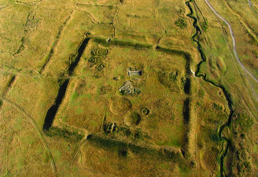
Archaeological research in the South-West Zhetysu discovered a kind of monument - a "tortkuls", or quadrangles, which can trace the development of urban culture. One of the monuments that reveals such a way of forming the city is the hillfort of Okhkhum. It is located on the right bank of the Garabaghr River, 1.5 km above its confluence with the Talas River. Visual inspection, as well as the study of aerial photographs allow characterizing the monument as a very complex structure in terms of topography. The inner fortification has the form of a square one (250×250 m) in terms of a 3-4 m high platform, oriented on the sides of the world and surrounded by a berm. The height of the rampart is 4-4.5 m, the thickness of the base is 18 m, and at the top it is 5 m. Towers up to 5 m high are located on the corners and along the perimeter of the walls, protruding outside the wall line. There are a total of 14 towers, including four corner towers.
The central part of the hillfort is a quadrangular platform, oriented by corners on the sides of the world. The size of the site along the crest of the surrounding rampart was 155×160 m. The rampart has been preserved to a height of up to 5 m with the width of the base 11-15 m. At the corners and along the perimeter of the walls, there were seven towers on the northeast wall (including the corner ones), six on the northwest wall, nine on the southeast wall, and nine on the southwest wall. In each of the four sides of the gate are guessed in the form of ruptures in the rampart. The entrances were connected by the roads intersecting in the center.
Inside the hillfort one can see the sagging in the form of oval hillocks. In the center of the hillfort there are three ponds-houses connected with each other, round in terms of excavation.
The central ruins are adjacent to the territory surrounded by a rampart with towers. The outer rampart looks like a rectangle with the length of the sides 290-330 m, and the south-eastern rampart consists of two sections closed at a blunt angle length of 200 and 160 m. In the middle of the northeastern part of the rampart there is a rupture - the remains of the passage.
Around the fortification to the south and south-east, along the Sulutor Gorge, there are sections of rectangular, square and irregular shapes, separated by stone boulders. An array of these sections stretches up the banks of the Sulutor, its total area is about 500 hectares. In a number of cases, there are "roads" that defuse the general haphazard building.
The excavation on the territory of the central settlement partially opened a rectangular building in the plan, oriented on the sides of the world. The bases of the walls are made of stone cobbles. Cleaning of the base showed that the wall itself was earthen-bit, about 1 m thick. The entrance to the building was decorated with two protrusions of the wall, which formed a vestibule.
On the surface of the floor, cleared on separate sites, the system of stone bases of columns is found. Two of them are blocks displaced from massive blocks of stone. The first one (0.5×0.5×1.3 m) has a slightly rounded lower part and chamfered from two corners, one side of which is decorated with carved ornaments. On one side of the block there is a figure in the form of a vase leg, which shows a sheet with two curls coming from the petiole. The second block is trapezoidal, with a ledge. Its two edges have been chamfered, and the images of anthropomorphic creatures are carved on two sides. The third base is in the form of a two-stage block.
The other 11 bases are massive blocks of stone, forming regular rows with distances of 3-3.5 m from each other. Thus, the total area of the yard should be either 55 or 66 bases of columns. Judging by the layout and the presence of the bases of the columns, it was a rectangular structure with a flat ceiling, which apparently rested on a large number of columns, part of the stone. Some of the bases were specially squeezed out of stone blocks and decorated with carved ornaments, while others were raw large boulders. Most likely, the remains of the building belong to the mosques of "pillar" type, typical for the early stages of development of Islam. On the territory of Kazakhstan a similar mosque was excavated on the ancient hillfort of Kuiryktobe on the Syrdarya River. The mosque of the X-XII centuries is dated to. Buildings of "pillar" type are also known in Central Asia.
The ceramics found during excavations of the mosque and the house are represented by fragments of thin-walled pots made on a circle, fragments of water-bearing and dining jars, and hummocks. A similar ceramics is known from the materials of excavations of Semirechensk hillforts in the layers of X - early XIII century.
Outside the central fortification in the south-western part of the area, surrounded by an outer rampart, there was a hill 1.5 m high and 30 m in diameter. The excavations revealed two multi-temporal structures, the upper of which was the remains of the mausoleum. The walls made of mud brick are preserved. The mausoleum is oriented by the walls on the sides of the world, square shape, the outer bypass of the walls with the dimensions of 7.5×7.5 m. The floor of the mausoleum was paved with rectangular burnt brick. It was used as a collective burial place in the crypts made of mud brick. The crypts from above were overlaid with two rows of bricks placed on a rib, forming a "herringbone". The overlapping of the mausoleum was flat. At the southern wall there were found charred slabs: one whole and a piece of board. The boards were covered with carved geometric and plant ornaments. The motif of the semi-palmette in the arch is repeated. The arch itself is inscribed in a rectangular field, in the corners of which are depicted vegetable curls. The bottom plan consists of a heart-shaped figure with a twisted top and antennae in the corners of the rectangular field. The fragment of the third board is decorated with two small medallions, divided into five parts by lines and protrusions.
Study of the topography of the ancient hillfort of Ornek and excavations on it give an idea of the center of sedentary life and craft. At the same time, the presence of powerful fortifications, a cathedral mosque, and a rich mausoleum testifies to the fact that the hillfort is the remains of the city, which was formed on the basis of the nomadic rulers' rates. Arab routes, in particular, compiled by Ibn Hordadbeh and Kudama, show that between Taraz, Lower Barskhang and Kulan, whose location is clearly defined, were located the cities of Kasribas, Kulshub and Julshub. Most likely, Ornek corresponds to Kulshub, which, like Kasribas, belonged to the Karluks and was at first the rate of one of their owners.
Archaeological materials from the excavations of Ornek allow us to suppose that the stakes appeared on the place of permanent sedentary settlement, apparently, on the territory of spring and autumn pastures. A part of the population on the fenced fields grew bread. The strengthened rate, in turn, served as the nucleus around which the city gradually formed. This process was stimulated by international trade along the Great Silk Road.
The presence of a mosque, a mausoleum with a rich interior testifies to the spiritual role of the city of Kulshuba, which was the sacral center of one of the Karluk tribes.
It should also be noted that the ancient settlement of Ornek is included in the UNESCO World Cultural Heritage List.