Information
- Location
- Kyzylorda Region, Aral District
- Period
- 1100 – 1400
- Kind
- Archaeological sites
- Authors
- Воякин Дмитрий Алексеевич
Sources
- Қазақстанның киелі орындарының географиясы: Табиғат, археология, этнография және діни сәулет өнері нысандарының тізілімі / Жалпы редакциясын басқарған ҚР ҰҒА академигі Байтанаев Б.Ә. – Алматы: Ә.Х. Марғұлан атындағы Археология институты, 2017. – 1-шығарылым. – 904 б.
Description
Discovery of monuments on the bottom of the dried Aral Sea testifies to the unique adaptability of the ancient population of the region to the environmental situation of high degree of aggressiveness.
The magnificent tomb, richly decorated with majolica and glazed carved bricks, is reminiscent of the pearl of medieval Khorezm - the mausoleum of Najmeddin-e-Kubra in Kunya Urgench. It shows not only the rich spiritual world of Aralasar's inhabitants, but also testifies to their preservation of traditions and reverence of their relatives regardless of the circumstances.
The sacred significance and symbolism of these, without any doubt, outstanding medieval monuments lies in the love of our ancestors for their land, remaining in their homeland, honoring their predecessors and striving to change life for the better, despite the changing environment. The current landscape situation - the vast expanses of the absolutely flat bottom of the Aral Sea and the archaeological monuments located on its surface, convey an indelible aesthetic feeling, bordering on the level of surprise and delight.
Aralasar settlement
The settlement, conventionally called Aralasar, is located 65.2 km from the modern village of Karateren, located 370 km northwest of Kyzylorda. This village stood on the bank of the Aral Sea in the last century, but now the sea has left it for 120 km. The remains of the medieval settlement, its construction structures are now poorly distinguishable on the surface. Raw architecture, which prevailed in the urban development, is actually completely blurred and smoothed by the waters of the Aral Sea. The 2-2.5 m wide irrigation canal passing through the settlement testifies to the developed irrigation system and the fact that the residents "pulled" water here, apparently, from the channels of the mouth of the ancient Syr Darya. The total area of the settlement is about 6 hectares. The surface, on which a large number of evidence of once thriving economic activities - millstones, ceramic vessels, fragments of iron and bronze products, is a layer of sand and shells. The thickness of the layer is 15-20 cm. Thus, the horizon, which contains traces of the territory's habitation, remained buried.
The central part of the settlement (190×136 m) of oval shape, stretched along the north-south line with a slight deviation to the north-west, is a flat surface. Minor hills show signs of development. From the northwest, the settlement is clearly confined to a dried bed and fields. Fields, canal remnants, riverbeds and a large number of stone, round-shaped millstones (15 pieces) with a diameter of more than 1 m mark the so-called production zone. This area is surrounded by residential development on the north-western side by a crescent. From the south and southeast sides of the settlement is limited to a necropolis, which is long part oriented on the west-east line. The size of the necropolis is 400×110 m. The area of the necropolis is readable by the concentration of fired brick scattering, which appears to have laid the floor of the mausoleums and the construction of cakes.
The structure-forming elements of the archaeological landscape are two branches, defined as the Syr Darya riverbeds, and the so-called canals located between these channels. The canals are connected to the southern arm at a negative angle and are fixed to the northern arm at a positive angle. The fields are visually distinguished as splattered shafts and represent separate rectangular checks designed for grain growing. Approximate field dimensions are 12×85 m. Fields are separated from residential areas by a duct (or artificial channel). Channels limiting the area of the field on the north and south sides are fixed on the surface as insignificant earth ramparts. Their width is 5 m, height 20-30 cm.
Two silver coins minted in the Golden Horde and dated to the middle of the XIV century were found on the settlement (the coin of Sarai-al-Jadid, the names of Zhanibek khan (1341-1357) and Nauruz-bek (during the reign of 760-761 /1358-1361)). Agriculture was one of the occupations of the settlement's inhabitants, who mainly cultivated grain crops. Water-loving weeds, pollen of which was recorded by palynologists, indirectly testify to the possibility of growing rice crops by the population of the Aral Asara. Findings of a great number of millstones and premises for storage of flour - humdans, where there were ceramic vessels - hummas, testify to the developed flour milling production.
Kerderi-2 mausoleum
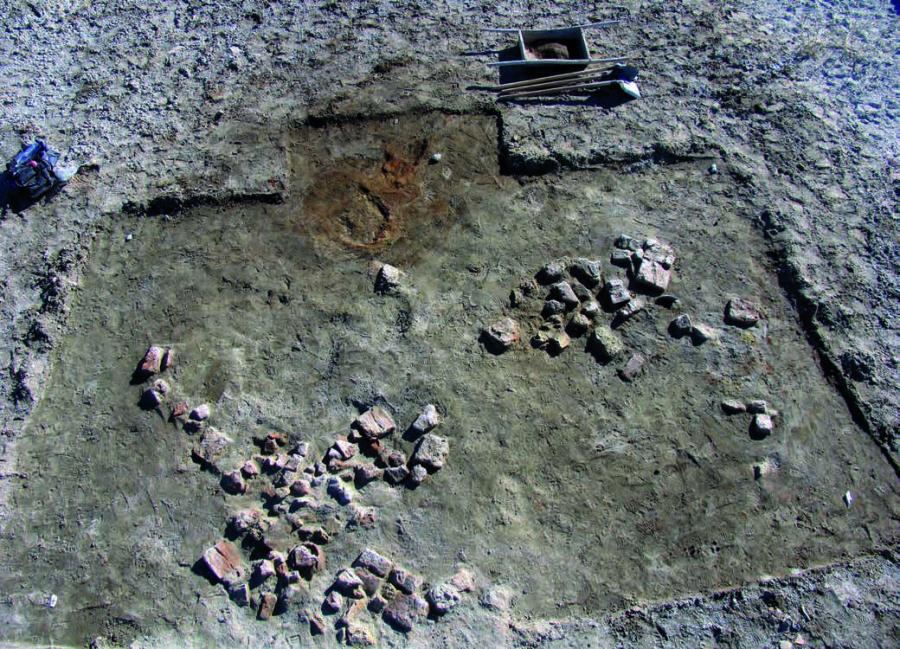
The structure before excavation was a floating hill 1.6 m high. The western side of the hill is flat, the eastern side is steeper. On the surface of the hill, a large number of burnt square bricks measuring 25×25×5 cm and debris were found. Archaeological research has revealed that the mausoleum is oriented by corners on the sides of the world and has the shape of a rectangle. The walls of the mausoleum were laid out with a plinth (25×25×5 cm), in large quantities found on the surface of the hill. The maximum preserved southwest wall is traced at a height of six rows of bricks.
The mausoleum consisted of a square chamber (gurkhana) with sides of 5.5 x 5.5 m. The entrance to the mausoleum was on the western side and was decorated as a portal that was once lined with sky-blue and blue irrigation bricks decorated with floral, geometric ornamentation and epigraphy. Of course, the building was dome - the dome was crowned with a gurkhana's room. Fragments of decorative rounded bricks found here suggest that the archivolt (framing of the archway) of the niche arch was based on three-quarter columns built into the corners of the niche. Apparently, the inner walls of the gurkhana were decorated with four deep axial niches about 1 m deep. In the southeast niche there was an entrance, and in the northwest, deeper niche there was the main burial of the mausoleum. The floor of the room is covered with rectangular slabs 44×27×6.5 cm. In the burial sites, either half of the floor bricks or standard size bricks are used: 25×25×4 cm. The floor brick was laid on dense loamy soil of brown colour. The floor tiles, which are clearly visible in the inner line of the outer walls of the mausoleum, opened the foundation, which was composed of stone blocks. The foundation of the mausoleum is 1-1,2 m deep and consists of massive stone slabs of sandstone (20×30×15 cm up to 100×50×25 cm). Such high strong base is not typical for similar constructions of the Central Asia where the complete absence of the base was often practiced also. Here one should take into account muddy (unstable from the point of view of construction) soil. It is also necessary to note the factor of wall thickness, which in the narrowest place reaches 1 m. In the portal part the width of pylons is 3 m.
Seven tombs were discovered in the mausoleum, all of which were widespread in the XI-XIV centuries type - sagan. All the dead were buried in wooden coffins. The only exception is burial No. 1, located in the north-western axial niche. The burial was looted nowadays. The construction of this burial seems to be interesting and unusual for this time. It is laid out with stones in the form of cyst and covered with three massive slabs. Human remains and artifacts in this burial were not revealed. In one of the burials earrings in the form of a cat's predator biting its tail were found. In the southwest corner of the gurkhana, under the tiled floor, a treasure of metal products was found - sickles, braids folded into the hoom. The mausoleum and necropolis of the XIV century are dated. The remains of three brick-fired furnaces where the bricks for construction were made are found near the building.
Archaeological study of Kerderi-2 gave an idea of the magnificent decoration of the latter. The most interesting of the finds are the fragments of glazed terracotta slabs with carved ornaments. Comparative analysis of fragments of decorative plates shows that this ornamental style and technology are inherent in Central Asian (Khorezm), and if wider - Golden Horde monuments of the XIV century. The plates, apparently, the main ornamental belt on the U-shaped frame of the portal are made in a combined technique of carved glazed terracotta and stamp. The first plan of the pattern in the form of a complex weave of geometric ornamental girikh is obviously corrected by carving, and small sockets and vignettes of the second plan are imprinted with a stamp. The artistic effect was achieved by shimmering with different shades of turquoise watering.
The settlement of Aralasar and the mausoleum of Kerderi-2 are monuments of history and culture of the Republic of Kazakhstan of local importance.