Information
- Location
- Zhambyl Region, Jambyl District
- Period
- 701 – 900
- Category
- Historical and cultural monuments of international significance
- Type
- City
- Kind
- Archaeological sites
- Authors
- Байпақов Карл Молдахметұлы
Sources
- Қазақстанның киелі орындарының географиясы: Табиғат, археология, этнография және діни сәулет өнері нысандарының тізілімі / Жалпы редакциясын басқарған ҚР ҰҒА академигі Байтанаев Б.Ә. – Алматы: Ә.Х. Марғұлан атындағы Археология институты, 2017. – 1-шығарылым. – 904 б.
Description
It is located 40 km east of Taraz and 6 km south of Aksholak station, at the foot of the Kyrgyz Alatau (Zhambyl region). This place is now a dry foothills, rugged with drying streams, the sources of which - springs - are located in mountain gorges.
Akyrtas is described as a historical monument by the Taoist monk Chan-Chun in the description of his trip to Genghis Khan in 1221-1224, whose headquarters were located in the valley of the Amu Darya near the city of Balkh. On his way to the west, he visited many towns and places and wrote about one of them: "A town made of red stones was opened; there were traces of an ancient military camp. This "city of red stones", according to researchers, was the ruins of Akyrtas. According to one of the legends, the city was built by Manas and his son Simai. After the death of Manas Simai settled on the bank of the Talas River, 25 km away from the city of Aulie-Ata. When he died, his bones were used to build a bridge across the Talas River in Tek-Turmas.
The history of studying of Akyrtas lasts more than 150 years. The first who paid attention to it was the Russian artist M.S. Znamensky. As a member of the military expedition of General M.G. Chernyaev in 1864 he visited the ruins of Akyrtas and left interesting sketches of panorama and fragments of walls. Then in 1867 the monument was examined by the famous orientalist P.I. Lerh. He gave a preliminary description, made measurements of individual blocks and gave information about the ruins of Akyrtas, collected by Chan-Chun at the beginning of the XIII century. P.I. Lerh considered Akyrtas a Buddhist monastery. A few years later the research was conducted by geologist D.L. Ivanov. In his article about Akyrtas there is a detailed description of the construction plan, quarries, where the stones were taken for construction. He also gave a description of the wall blocks, made sketches of ornamented ones.
A member of the Turkestan group of archeological amateurs, V.A. Kallaur, exploring Akyrtas, found water pipes, stone gutters and came to the conclusion that the water was brought to the construction of springs located 4-5 km above - in mountain gorges. At the same time, the question was raised about the identification of Akyrtas with a specific settlement mentioned in written sources, in particular in Ibn Hordadbeh and Kudama. They are the ones who provide the most detailed register of cities on the trade route from Taraz to Kulan in their road maps. This is the lower Barskhan in three farsahas from Taraz, then two farsahas Kasra Bas (Kasribas), then two farsahas - Kul-Shub, then four farsahas - Jul-Shub and Kulan, to which "was the path of four farsahas".
V.A. Kallaur identified Akyrtas with Kasribas. Later, interest in Akyrtas did not disappear, in particular, he found himself in the field of view of the works of the Semirechenskaya archeological expedition headed by A.N. Bernstam, which worked in the Talas valley in 1936-1938. Then in 1940, 1945-1946 G.I. Pacevich investigated Akyrtas, who dedicated an article to the monument. He characterizes the topography of Akyrtas, describes the premises, courtyard, bases of the columns. He also describes quarries where stones were broken and writes about water supply. According to G.I. Pacevich, Akyrtas dates back to the IX century and, most likely, is similar to Nestorian buildings.
In 1945, the monument was studied by the Expedition for Architecture under the Council of Ministers of the Kazakh SSR. The result of her work was the plan of Akyrtas, and research materials are summarized in an article by architect T.K. Basenov. The published plan of Akyrtas is of interest. T.K. Basenov rejects attempts to consider Akyrtas a Buddhist or Nestorian monastery, assuming that Akyrtas was a palace-fortress built in the VIII-IX centuries.
An attempt to interpret the materials of the hillfort belongs to L.Yu. Mankovskaya. Having analyzed the construction plan, the author believes that the monument is a caravanserai with a central courtyard and small yards of different purposes. It was built as a giant shopping mall and a transshipment point. L.Yu. Mankovskaya dates the beginning of construction no later than the X century and joins the opinion about the identity of Akyrtas - Kasribas. Finally, another attempt to explain the purpose of Akyrtas, the time of its construction and related political events was made by the German researcher V. Brenthes. He believed that Akyrtas was built by order of the Arab commander Kuteiba. In his opinion, the researcher names the exact date of the beginning of construction - 714-715, when Kuteiba ibn Muslim became the ruler of the north-eastern areas of the Caliphate. Akyrtas was built as his residence in the north. Thus, there are different versions about the time of the beginning of the construction of the complex, its purpose and identification with a particular locality.
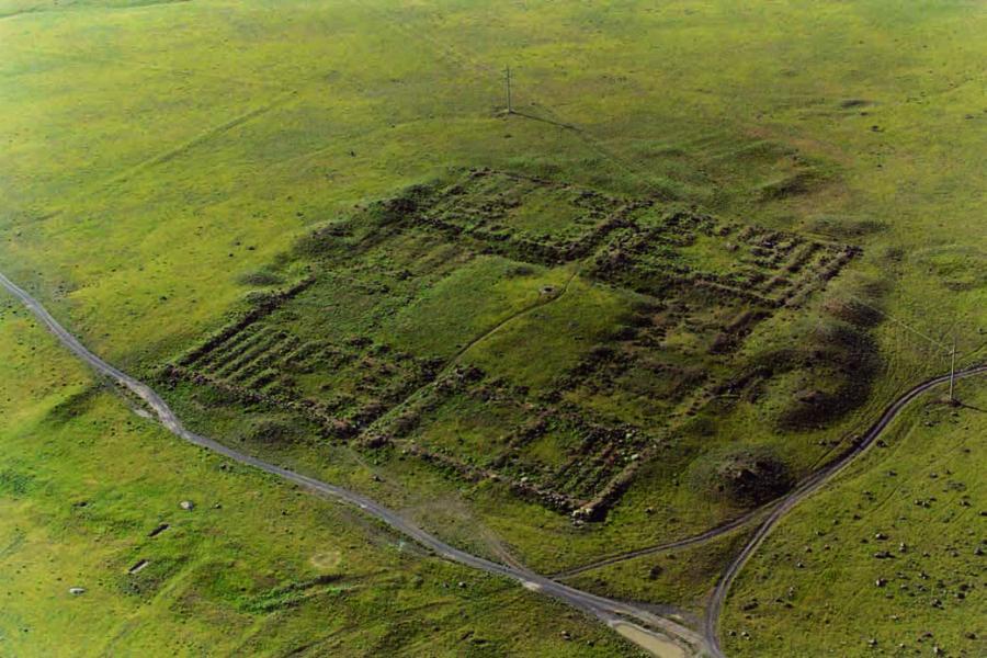
Archaeological research in 1996-1998, conducted by Kazakh archaeologists in cooperation with French researchers, revealed a number of details that allow to put forward another version. First of all, it refers to the definition of "yard" in the north-eastern part of the building. It turned out that it was intended to accommodate a mosque here. During the excavations it was established that in the western wall of the "yard", on the site of the previously assumed passage, was probably the base of the mihrab. In the northern wall of the courtyard, which was previously considered deaf, three tambourine passages connecting it with the street were cleared. The presence of several passageways testifies to the public purpose of the building, which was a mosque. In addition, on the site of the "yard" there were specially processed bases of columns. Perhaps, the mosque was to be a pillar (multi-column). Such mosques are among the earliest in Islamic architecture, their peculiarity is the presence of a large number of columns set in rows, each of which is 3-3.5 m away from the neighboring one (column pitch). The flat roof was based on these columns.
Similar mosques are known in Southern Kazakhstan and Zhetysu. One of them was excavated on the hillfort Kuiryktobe, the second - in Ornek, which is located 20 km east of Akyrtas. Both mosques are dated to the IX-X centuries. If we consider that in Akyrtas there was a mosque, it removes the assumption of Nestorian and Buddhist purpose of the whole complex, and also clarifies the time reference points.
Islam began to penetrate Zhetysu in the middle of the VIII century, the age of Akyrtas is confirmed by the lifting ceramics from the area around the central part of the city, which was once occupied by residential buildings, brick-fire shops and quarries. The analogies of ceramics can be found in the complexes of dishes from Taraz, dated the VI-VIII centuries.
Akyrtas - unfinished monumental construction, rectangular in plan, walls are laid out of massive stone blocks of red sandstone, erected at a height of 1 to 1.5 m. The blocks were placed in 1-2, less often in 3-4 rows. The construction plan of 180×205 m, oriented from north to south on long sides, is well readable. The main street connects the northern and southern entrances. Perpendicular to it from east to west passes another street, resting in deep iwans. The streets divide the building into four parts, three of them consist of rooms around courtyards, and one (northwest) is free from construction. In the center of the yard, along the perimeter of the yard there are stone bases of columns with the size of 5×5 m. In the southern part of the yard there are excavations of two reservoir-houses. The outer walls of the building are 5 m thick and are based on a foundation of stone blocks, the height of which is about 2 m. An interesting technique of laying external walls: they consist of a case made up of blocks, and in between they are filled with crushed stone and clay.
It was possible to find analogies to the layout of Akyrtas - they lead to the architecture of the Near and Middle East. The layout of the palaces of Samarra, the summer residence of Arab caliphs, the palaces of Syria and Jordan, in particular, the magnificent Qasr al-Hair al-Ghari palace, was very similar. All this makes us look at Akyrtas as a palace, which was supposed to become the summer capital of the ruler. It could be the Karluk kagan - the Karluks ruled the western part of Zhetysu from 766 to 893.
The eastern side of Mount Kyzyltas was used for breaking stone: there was a quarry that stretched for 400 m. Tens of boulders, treated and semi-treated blocks are still lying there, dumps of broken stone and crushed stone are rising. The distance from the quarry to the construction site was about 200-400 m, and on this way it was necessary to drag the stones through the channel, on which flows a small river, drying up in summer and autumn. It is possible that the transportation of boulders and blocks was carried out mainly in winter, when it was possible to use sleds made of thick logs.
Previous studies have shown that Akyrtas was supplied with water through water pipes that had fences from springs of Shoshkaly and Uzunbulak gorges. The distance from here to Akyrtas is at least 2-4 km. The water flowed through clay pipes 50-60 cm long. The diameter of the wide end of the pipe was 20 cm, and the narrow end was 18 cm. The narrow end of each link was inserted into the wide of another one. The water pipe started from a reservoir constructed with the help of dams blocking the gorge in a narrow place where there were rock outcrops on both sides.
Studies have shown that the water supply network was complex. The water supply system was cleaned in the section near Akyrtas and in the section of the water supply to the reservoir (house). The water was discharged from it to residential houses and estates with swimming pools in their yards. Water was distributed using smaller diameter pipes.
To the north of Akyrtas there were two reservoirs. The volume of one of them, the western one, was 3,200 cubic meters of water. The eastern reservoir was slightly smaller in volume. Apparently, the water accumulated here was intended for irrigation of crops located in the areas north of Akyrtas.
To the east of Akyrtas, a rectangular plot of 250×250 m in size was found surrounded by a wall. From the east, it is adjacent to the streambed, which is now a spring water stream. In addition, it is approached by the canal channel stretching towards Shoshkaly. Most likely, the park-garden, similar to the ones that existed in the palace complex, was supposed to be laid out in this square, or maybe it was already laid out.
The system of observation of the surrounding area and warning of war danger was studied. On one of the peaks of Kyzyltash there was built an observation tower made of stones. Only the lower row of masonry, which forms a circle with a diameter of 5 m, has been preserved from it, and there is a stone platform - a place for a signal fire.
Akyrtas is one of the most mysterious monuments of South Kazakhstan, included in the UNESCO World Heritage List.
Nowadays Akyrtas is one of the places of religious worship, first of all, Muslims, and also a place of visit and residence of numerous psychics. Undoubtedly, the presence of the earliest mosque in Kazakhstan makes this monument sacred.