Information
- Location
- Zhambyl Region, Shu District
- Period
- 401 – 1300
- Category
- Historical and cultural monuments of international significance
- Type
- City
- Kind
- Archaeological sites
- Authors
- Байпақов Карл Молдахметұлы
Sources
- Қазақстанның киелі орындарының географиясы: Табиғат, археология, этнография және діни сәулет өнері нысандарының тізілімі / Жалпы редакциясын басқарған ҚР ҰҒА академигі Байтанаев Б.Ә. – Алматы: Ә.Х. Марғұлан атындағы Археология институты, 2017. – 1-шығарылым. – 904 б.
Description
One of the remnants of large cities on the Great Silk Road is the so-called White Hill - the hillfort of Aktobe, located on both sides of the Aksu River, not far from its confluence with the Shu River in the steppe zone of Zhetysu. Nowadays it is the territory of Kurdai district of Zhambyl region. In 2014, the monument was inscribed on the UNESCO World Cultural Heritage List.
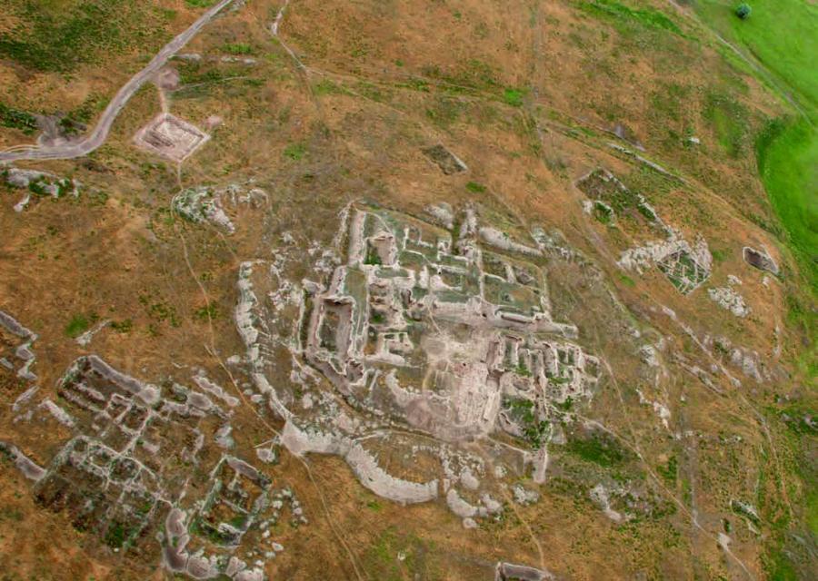
Aktobe is a visually challenging object that occupies a large area surrounded by walls. The central ruins that gave the name to the monument are located on the left bank of the Aksu River. The citadel looks like a high rectangular hill with a height of 15 m, oriented by corners on the sides of the world. The size of the hill at the base is 100×120 m. The citadel is adjoined by shakhrestan of 210×240 m in size. Both the citadel and shahrestan are surrounded by walls, from which the shafts have survived.
The central ruins are adjacent to the territory of the craft and agricultural district, surrounded by two rows of ramparts. The inner rampart limits the area with denser buildings than the one observed in the space between the inner and outer ramparts. The length of the district along the river along the outer ring of the walls is 9.5-10 km and 5.5 km along the inner ring of the river. Inside the hillfort territory, despite the seeming chaos of construction, has a clear layout. The residential estates (house and yard) are stretched in the direction of the river flow and are located in rows so that the rears of the estates standing in the neighboring rows close up. The area of the plots varies from a quarter of a hectare to 1-1.5 hectares.
Archaeologists studied a group of three estates. Aktobe 1 consists of a residential complex and a courtyard. The area of the estates is 0.4-1.4 hectares. The residential houses of the estates consisted of several rooms where souffes, niches in the walls, fireplaces on the floors were arranged. A small amount of material was collected during excavations of manors. Interesting is a copper coin with a square hole in the center. Its safety is bad, it probably belongs to the circle of Sogdian coins. The estates are dated to the VII-XII centuries. Since 1974, an archeological expedition of the Al-Farabi Kazakh National University has been working on the Aktobe hillfort. On the citadel, which existed throughout the V - XII centuries, the remains of the castle of the VI-X centuries, which had a typical for the early Middle Ages comb layout, and above it - in the layer X - early XIII centuries - the remains of the palace complex, consisting of 13 rooms of ceremonial, residential and economic purpose.
Among the excavated objects in the suburbs were opened three wineries. A unique find on the hillfort is a piece of clay vessel with an inscription in Sogdian. One of the most important objects of the settlement is the remains of a mosque minaret built of burnt bricks. The presence of the minaret dated to the XI-XII centuries indicates the functioning of the mosque in the city. The question of identification with any medieval town of Zhetysu, known from written sources, is not solved unambiguously. Professor U. Kh. Shalekenov believes that Aktobe is the remnants of the city of Balasagun. According to numismatist P.N. Petrov, based on the study of treasures of coins, these are the remains of the city of Kadiriya.
The hillfort is a monument of world importance. It is connected with the history of the ancient Turkic states: Western Turkic, Turgesh, Karluk Kaganates and Karakhanid state.