Information
- Location
- West Kazakhstan Region
- Period
- 1201 – 1499
- Category
- Historical and cultural monuments of republican significance
- Type
- City
- Kind
- Archaeological sites
- Authors
- Байпақов Карл Молдахметұлы
Sources
- Қазақстанның киелі орындарының географиясы: Табиғат, археология, этнография және діни сәулет өнері нысандарының тізілімі / Жалпы редакциясын басқарған ҚР ҰҒА академигі Байтанаев Б.Ә. – Алматы: Ә.Х. Марғұлан атындағы Археология институты, 2017. – 1-шығарылым. – 904 б.
Description
It is located 10 km south of Uralsk on the right floodplain terrace of the Ural River (West Kazakhstan region).
The West Kazakhstan region on the historical map of Kazakhstan until recently remained a "region of nomadic tribes" that did not have their own settlements and towns. In 2001 the Ural archeological expedition has started searches and researches of medieval cities and settlements. The expedition was organized by the Institute of Archeology named after A. Kh. Margulan with the support of the regional akimat, the Regional Historical and Local Lore Museum and the West Kazakhstan Center of History and Archaeology. The expedition was led by K.M. Baipakov. New direction for the region - study of medieval city culture - was connected with works on open expedition of medieval hillfort. The area of Zhaiyk hillfort is preliminary determined in 7-9 hectares. It has no artificial defensive structures in the form of ramparts, walls, moats. Natural ravines and the banks of the river channel served as borders.
The hillfort is characterized by estate building. The estates were separated by gardens, water reservoirs and canals, which were free from building plots. Excavations of three hillocks have shown that the ruins of residential complexes of detached estates are hidden under them. The buildings were erected from mud brick of rectangular and square shape. The living quarters were heated with cans - a heating system with heat conducting channels under the sufa beds connected to the furnace, which is usually tandoors. In addition to them, rectangular stoves made of baked bricks were used in the "big estate" and one of the "small estate" dwellings. Living quarters have U-shaped sufas along three sides, household pit storage facilities, garbage pits, tashnau. The thickness of the main walls of the buildings is 70-80 cm, and the brick is laid at the intersection. Comparison of plans and techniques of housing construction in the Volga region cities and the Zhaiyk hillfort shows that the construction culture of the cities in the Ural River basin has been dominated by the traditions of house-building in Khorezm and the Syr Darya region oases. The plans of the dwellings studied on the site of the hillfort generally coincide with the plans of the post-Mongolian Urgench, Otrar and Turkestan dwellings. The difference is observed in the location of some interior details and in the heating system.
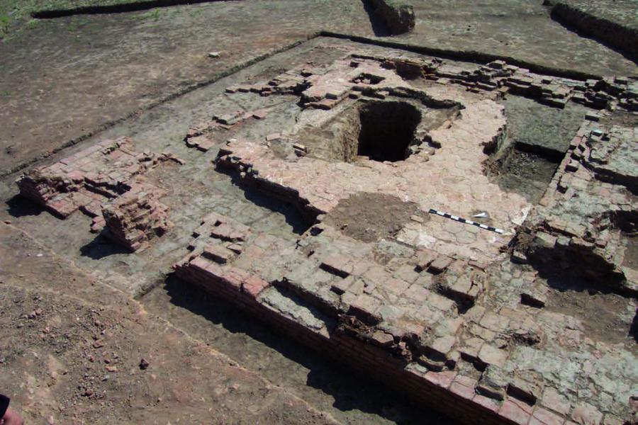
The fact that there was a developed city on the site of the Ural hillfort in the XIII-XIV centuries is evidenced by the ruins of the eastern bath, which was an indispensable attribute of the medieval city in the East. Unfortunately, the building was almost completely destroyed after it ceased to function. High-quality baked bricks made of walls and floor were broken out for secondary use. However, the study of such structures in Central Asia allows, relying on analogies, with a certain degree of confidence to reconstruct its appearance. In the XIII-XIV centuries baths acquired a complete planning structure and were built as if on a standard project, which crystallized the most rational organization of such a specific purpose of the structure. The central hall of the Zhaiyk bathhouse had an octagonal layout. From the east and west it was adjoined by small rooms for washing. The bathhouse was heated by an underground heating system. Heat conducting canals were arranged under the floors of all interior rooms. The basement of the whole building was at least 1.4-1.5 m deepened underground. Water was supplied to the washing rooms by means of an extensive system of ceramic pipelines.
The analysis of ceramic material and other finds gives grounds to date the time of existence of the city at the end of XIII-XIV centuries. Topographical features and excavated objects indicate that this place was a major city of the Golden Horde epoch. This is confirmed by numismatic findings. The found coins belong to the period of Djuchid Khan of Uzbek (1336-1337).
The existence of the city on this place is also conditioned by natural and geographical conditions. In the area of the Melovye gorki (Cretaceous Hills), located 3 km northeast of the hillfort, there were the Nizhnemelovoi and Verkhnemelovoi perekats (rolls), which served as fords, on the Ural River. The existence of a large city in the bend of the Ural River (in the X century the river was called Jakha, or Jaik-Zhaiyk-Yaik) is confirmed by the map drawn up in 1367 by the Italian merchants of the Pizigani brothers, as well as the map of the English captain Anthony Jenkinson, drawn up in 1562, that is, almost 200 years later. The XVI century map also shows the name of the city, probably distorted by "Shakafni".
The discovery and study of the Ural hillfort naturally raised the question of the location and study of its necropolis. In the area of the settlement on the surface of the hillside of Svistun Mount, which looks like a flat plateau about 3 km wide, it was chosen by the townspeople as a necropolis. Here were fixed ploughed barrow-like hills, on which were found fragments of baked brick. Three such hills were investigated, under which, as expected, the ruins of memorial buildings are hidden. The remains of the two-chamber mausoleum built of baked square bricks and lined with polychrome glazed tiles are completely cleared.
Outside the mausoleum had the shape of a parallelepipedal with the size of 9×12 m, it is crowned with two domes. The southwest wall was probably a portal. The entrance in the centre of the portal niche (iwan) led to the first room, which was a ziyaratkhana. To the left and right of the entrance to this room there were low sufas along the eastern and western walls. The passageway then led to a second room measuring 5.5 x 5.5 m, which was a tomb (gurkhana). The interior of this room was decorated with glazed blue tiles with epigraphic gold paintings. The only burial place in the gurkhana is located almost in its center, in front of the sufa by the northern wall. It is completely plundered, even most of the bricks from the tomb crypt are taken out. Most of the bones of the buried skeleton are also missing. In the rubble of the grave, fragments of burnt bricks, pieces of decayed wood were found. An iron chair, forged iron nails from the coffin, bronze bells, a small iron knife and a cone-shaped iron bell were found in the layer above the floor. As it is known, a similar type of mausoleums (portal-dome longitudinal-axis two-chamber) was formed in the second half of the XIV century, and by the end of the XIV century creative search for architects in this form of buildings reached its climax.
Under the next hill, the ruins of a large mausoleum, which were not well preserved, were also uncovered. The base of the portal was cleared, a fragment of the western wall of the building was found, the level of the courtyard in the pre-portal part was cleared, paved with square burnt bricks, two mud buttresses, which later were attached and supported the portal. The central room of the building covered by a dome had the area not less than 100 m2. The well-developed portal probably stood above the rest of the walls of the building, and on its edges stood the minaret towers. The exterior cladding of the building was dominated by blue, the portal was decorated with a blue-and-white scale ornament.
The end of the XIII - the first half of the XIV century in the history of the Golden Horde are characterized as the years of the greatest stability and prosperity of urban culture. Some of the most important trade and economic centers, which suffered during the conquest period, were revived, dozens of new cities and large settlements appeared.
This short period of intensive growth is mainly during the reign of the Khans of Uzbek and Zhanibek (1312-1357). It is well known that Islam officially became the state religion in the Golden Horde under the Uzbek khan (1313-1339). Probably from that time onwards, it was in different parts of the Golden Horde Empire, except for Central Asia, where Islam had been established long before that, that Islamic memorial-cult buildings of the Central Asian type appeared for the first time in mass scale. And it is not by chance that the coins found on the site of the ancient settlement belong to the minted Uzbek khan of 1336-1337.
Of course, Zhaiyk with his necropolis, consisting of ordinary graves and brick, decorated with irrigation slabs, mausoleums, was a sacred place. Here on the city necropolis noble people were buried. There was definitely a mosque in the city that had not yet been found. The city was a large political, economic and spiritual center in the valley of the river Zhaiyk (Ural), dates back to the XIV century.