Information
- Location
- Atyrau Region, Inder District
- Period
- 1801 – 1950
- Type
- Necropolis
- Kind
- Buildings of monumental art
- Authors
- Бекназаров Рахым Ағыбайұлы
Sources
- Қазақстанның киелі орындарының географиясы: Табиғат, археология, этнография және діни сәулет өнері нысандарының тізілімі / Жалпы редакциясын басқарған ҚР ҰҒА академигі Байтанаев Б.Ә. – Алматы: Ә.Х. Марғұлан атындағы Археология институты, 2017. – 1-шығарылым. – 904 б.
Description
It is located 58 km away from Karabau settlement (Inder district, Atyrau region).
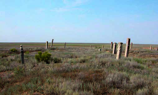
The Dari necropolis is located in a flat steppe area. From the northern outskirts of the cemetery at a distance of 70 m there is a gas pipeline "Central Asia-Center" and a field road built by the bypassers of this route. From the south of the necropolis at a distance of 5 km the Makat-Inder railway line was built. The cemetery occupies a sub-square area of 150×160 m, according to the chronology of monuments belongs to the XIX - early XX centuries. Apparently, the cemetery was developing from east to west: this is recorded both by the good preservation of the raw fences and by the epitaphs of kulpytases at them. On the necropolis there are no less than 100 visible old traditional monuments, most of which are now floating burial mounds and fences. The cemetery is particularly notable for its large mud fences with entrance openings on the southern side, located in the western part of the cemetery. Obviously, these are family memorials designed for several people.
Carved steles of kulpytases, represented by various varieties of flat and volumetric steles, are especially distinguished on the necropolis Dari. The material of their limestone sandstone is of different colors: from light yellow to dark grey, with a blue hue. The majority of kulpytases with rounded tops; on some steles the tops are decorated in the form of a crescent moon. There are also giant carved steles, with skilful processing of segments, details and decorations of planes, gravitating to the "elegant" school of Western Kazakhstan stone-cutting art. One of the kulpytases of the necropolis (object № 43) is used as a stela-shyrak (lamp), at the foot of the monument glass jars with melted animal fat are installed, and coins are left. A long wooden pole is leaned against the stele. In the decoration of stone-carved monuments, a great emphasis is placed on the texture and information part (epitaphs, tamgas); some of the kulpytases have characteristic images of weapons items ("bes qaru"). Technique of processing steles - heifer, two-sided, three-sided and openwork carving. In the northwest corner of the cemetery there is a wrought iron fence.
The necropolis was surveyed in 2004 by the West Kazakhstan Complex Ethno-Archaeological Expedition (WKCEAE, headed by S.E. Ajigali, head of squad - R.A. Beknazarov): measurements, photofixation, research of Arabic epigraphy, including the engraving of some inscriptions.
According to the epitaphs of kulpytases, the cemetery is a generic necropolis of the Kazakh Berish family, a subdivision of Karatokai. At the cemetery in 1869 was buried bi Eset Karauly (Eset Karin on Russian sources).
The cemetery is visited by pilgrims. The territory of the cemetery was cleaned, some broken trunks of stelescopes and their tops were reconstructed due to the use of modern cement mortar. Pieces of white matter are tied on several kulpytases.