Information
- Location
- Almaty District, Balkhash District
- Period
- 801 – 1300
- Category
- Historical and cultural monuments of international significance
- Type
- City
- Kind
- Archaeological sites
Sources
- Қазақстанның киелі орындарының географиясы: Табиғат, археология, этнография және діни сәулет өнері нысандарының тізілімі / Жалпы редакциясын басқарған ҚР ҰҒА академигі Байтанаев Б.Ә. – Алматы: Ә.Х. Марғұлан атындағы Археология институты, 2017. – 1-шығарылым. – 904 б.
Description
It is located 200 km north-east of the settlement of Bakanas, 3 km north of the confluence of the dry Ortasu riverbed into Shetbakanas (Balkhash district, Almaty region).
Assessing the results of the conducted archeological works on the ancient settlement of Karamergen and the interfluve of the Ile-Karatal, it is possible to note that in the lower reaches of the Ile River in the IX-XIII centuries there was a developed land-tilling culture associated with settlements and towns on the Great Silk Road from the Ile Valley to Central Kazakhstan. Caravans were probably ferried to the northern shore of the Balkhash River at the mouth of the Tokrau River on the ice of the frozen lake through a narrow strait 8 km wide, and in the years of regressions of the lake and ford.
It is interesting to analyze the topographic maps of this territory, drawn in the late 19th century: Map of Asian Russia with the adjacent possessions (Sheet IV, scale: 1 inch 100 versts, 1:42 000, published in 1884); Map of the southern border strip of the Asian Russia (Sheet XII, scale: in I inch 40 versts, 1:1 680 000, published in 1921). These maps show caravan roads along both banks of the Ile and Karatal rivers, along the Southern and Northern Balkhash region, as well as the way from the village (picket) of Sarybulak (the area of the present-day village of Koksu) to the west, northwest through the sands of Sary-Ishik-Otrau to the present-day delta of the Ile River. Then the caravan road went to Lake Balkhash (Sartumsy settlement). More than 10 overnight stays with wells are marked on the road section of about 300-350 km. The ruins of the fortifications of Aktam and Durtgut are shown quite precisely on the maps, which coincides with the location of the settlements of Karamergen and Aktam, respectively. In the Northern Pribalkhash region, just east of the present-day town of Balkhash, the "former Byrtysskaya pier" is marked, from which the caravan routes go north to Karkaralinsk and further to Semipalatinsk, Pavlodar, Akmolinsk.
It is also interesting to note that the canal of Shetbakanas to the latitude of the ancient settlement of Aktam is shown as active, with a constant flow. It is possible to draw a conclusion that at the end of the XIX century the caravan routes in the Southern Balkhash region were widely used and, apparently, acted since ancient times.
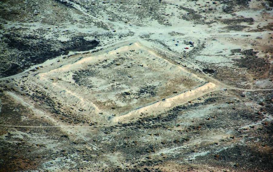
The settlement itself is a rectangle of 115×120 m, oriented by corners on the sides of the world, rising above the surrounding area by 2 m. It should be noted that the walls, which even now reach a height of three meters, and the towers, which are located in the corners, are well preserved and 5 meters high. The north-eastern and south-western sides have two more round towers 3.5 m high. Entrances to the settlement can be seen in the middle of the north-western and south-eastern walls. Their construction is complicated. They are flanked by the "Г"-shaped section of the wall, on the corners of which there are two towers, and the south-eastern entrance is fortified by a remote rampart, preserved at a height of 1.5 m. Karamergen is a single-layer settlement with a thickness of cultural layers of 0.5-0.8 m.
Cleaning of the western tower from the outside and excavations inside showed that it had a conical shape, narrowed to the top, where a 3-metre diameter shooting range surrounded by a brick lintel was built. The tower was built using raw brick. A section of the wall surrounding Karamergen was also cleared. It turned out that the wall was 4.5 m thick and made of raw bricks, plough blocks and pieces of raw clay.
From the southeast side of the settlement at a distance of 0.8-1 km passes the main canal, removed from the riverbed of one of the branches of the now anhydrous riverbed of the Ortasu River. The second canal is located 2 km west of the Karamergen and its riverbed runs from the southwest to the northeast of Lake Balkhash. The remaining length of the canal is 10 km and the riverbed width is 8-10 m.
Ceramics from excavations on the ancient settlements of Bakanas, as well as collected on the surface of the above described monuments, dates back to the IX-XIII centuries. These are pots, canteens and water-bearing jugs, mugs, bowls, large vessels for storing water, grain and flour - hums. Most of the vessels are made on a potter's wheel of dense, well mixed dough, with an admixture of fine sand and chalk. Ceramics were fired in pottery stoves, and the dough became dark red or dark brown when it was fired. The ceramics of the Bakanas settlements, especially the ceramics from Karamergen, have one exceptional feature - when firing it became dark brown, gray, almost black, and the shard became light and resonant. This is obviously due to the property of local clay or some mineral additives in the dough. From the surface of the hill forts, along with fragments of dishes, several clay tensions were collected, carved from the sides of broken vessels. Irrigated ceramics in the materials of the Bakanas hill fort are represented by several small fragments of bowls, such as pialas and kese. Poor quality grayish-white watering was applied over the white angoba and covered with dirty green, brown, reddish spots and stains from above. Paints of cloudy tones, watering itself rough and easily peeled off from the shards. Several fragments of white and brown glass vessels with a high content of air bubbles can be attributed to the XI-XIII centuries.
Due to its uniqueness and worldwide value, Karamergen is included in the UNESCO World Cultural Heritage List. But this monument, of course, has a sacral meaning. Located in the desert zone on the trade route, it was a place of reverence and worship of the population, which has been using the area of South Balkhash region as winter pastures since ancient times. The nomadic migration here was accompanied by the performance of religious rites, and after the desolation of the ruins of Karamergen was revered by the Kazakhs as a sacred place.
Sources
Байпаков К.М., Ефстифеев Ю.Г., Кок Б., Пачикин К.М., Савельева Т.В. Эколого-археологические исследования в Южном Прибалхашье (Северовосточное Семиречье) // АЭАЕ. – 2001. – № 6. – С. 112–122.
Байпаков К.М., Савельева Т.В., Чанг К. Средневековые города и поселения Северо-восточного Жетысу. – Алматы: Институт археологии им. А.Х. Маргулана, 2005. – 188 с. – С. 30–33.ф