Information
- Location
- Kyzylorda Region, Karmakshy District
- Period
- 1100 BCE – 401 BCE
- Type
- Necropolis
- Kind
- Archaeological sites
Sources
- Қазақстанның киелі орындарының географиясы: Табиғат, археология, этнография және діни сәулет өнері нысандарының тізілімі / Жалпы редакциясын басқарған ҚР ҰҒА академигі Байтанаев Б.Ә. – Алматы: Ә.Х. Марғұлан атындағы Археология институты, 2017. – 1-шығарылым. – 904 б.
Description
It is located 170 km south-west of Kyzylorda, 65 km west of Kyshboget village on the riverbed of Incardaria. It dates back to the first half of the I millennium BC. It was identified and examined in 1959 by the Khorezm Archaeological and Ethnographic Expedition (headed by S.P. Tolstov), and was re-examined in 2006 by the Chirikrabat Archaeological Expedition (headed by Zh. Kurmankulov).
The Tagisken burial ground is one of the monuments reflecting the diverse ethno-cultural processes in Kazakhstan and Central Asia. It is established that since II thousand BC in steppes of Eurasia there are difficult ethnic processes. They are conditioned by the migrations of mobile pastoralists - bearers of steppe bronze cultures. Archaeological monuments mark the directions of contacts of the population of northern steppe and semi-desert regions with the south of Central Asia, where the centers of proto-urban civilization are fixed. The need of pastoralists in the products of agriculture and highly developed craft of southern agricultural oases, and farmers in the products of animal husbandry determined the nature of ethnogenetic processes in Central Asia in the II - early I millennium BC.
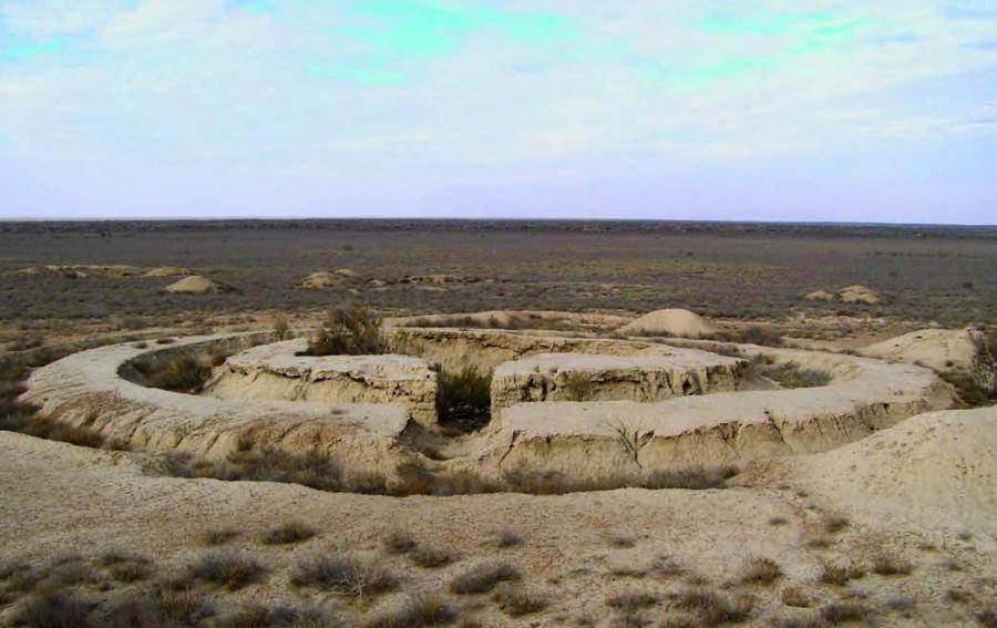
Archaeological works on the monument revealed complex burial structures - raw mausoleums, which were located on the northern side of the Tagisken plateau (XI-VIII centuries BC), and on the southern side there were burial mounds (VI-V centuries BC). Northern Tagisken is a monument of the late Bronze Age (X-VIII centuries BC) with ruins of complex mausoleums built of mud brick. The funeral complex is made of rectangular mud brick (54×28×10-12 cm, 48×32×10-12 cm), made of local root rock and having a reddish color. These are monumental funerary structures and special additions to them, built of mud brick. It demonstrates southern connections with oases of Central Asia. In the Northern Tagisken the rite of corpse burning dominated, which supposed not only burning of the deceased in the central chamber, but also a ring of fire around it. The layout of the mausoleums is a circle inscribed in a square, which eventually disappears and remains only a circle separated by a cross. Such a layout was characteristic of the Khorezm and Saka burials of the second half of the I millennium BC.
Signs of funerary structures typical of the Northern Tagisken include: burning of the surface of the site before the construction of the funerary structure; funerary "tables" surrounded by rectangular grooves; burning of the funerary structure; column pits at the corners of the funerary chamber; ring of fire around the funerary chamber. In the northern part of the hill there were also separate burial mounds excavated at present.
In terms of its geographical location, Northern Tagisken occupies an intermediate position between the steppe historical and cultural areas of the western and eastern areas (Srubna and Andronov), between the cattle-breeding and agricultural crops of the steppe north and the classical agricultural civilizations of the south of Central Asia. This geographical and chronological interrelationship makes the Tagisken Landfill a key monument for the development of various archaeological reconstruction issues.
The southern burial ground on the surface of the plateau was represented by barrow embankments. The mounds are composed mainly of sandy loamy soils, they have undergone severe erosion and almost no relief on the modern day surface. The Imperial Eagle contains the greatest number of Saka embankments dating back to the VI-V centuries BC. The burials on the ancient horizon, the number of which is about half of the number in the Imperial Eagle, are reminiscent of the simplest late Bronze Age burials in the North Tagisken. Located nearby, the well-known Uigarak burial ground is obviously left by the tribes related to the Tagiskens.
The population of the steppes of the Aral Sea region has been in constant contact with the population of agricultural oases in Central Asia for thousands of years. The mausoleums of Northern Tagisken were a brilliant manifestation of these connections. The construction of the mud bricks with the preservation of some construction techniques known from the Bronze Age continues to play an important role in the architecture of residential and burial structures of the lower Syr Darya Saks and later, including the second half of the first millennium BC.
Thus, the monuments located in the steppes of the Aral Sea region, demonstrate the continuity in the understanding of the places of ancient burial as sacred for several thousand years, the tradition of erection of mausoleums, the line of development of monumental and temple construction for thousands of years in the culture of the Great Steppe and Central Asia. Architectural methods of Tagisken mausoleums are dictated by worldviews and cosmological ideas of the ancient inhabitants of the region, mythological understanding of the space. The ideal model for funerary, cult and later temple buildings were the ideas of the ancients about the harmonious universe. It was based on the simplest forms - circle and square. The square also acted as one of the variants of the sacred hearth. In general, the construction of mausoleums demonstrates the existing cult of fire, ancestors, the attitude to the funeral structure - the mausoleum as a cult one.
It is a tourist attraction.