Information
- Location
- Kyzylorda Region, Zhalagash District
- Period
- 901 – 1400
- Category
- Historical and cultural monuments of republican significance
- Type
- City
- Kind
- Archaeological sites
- Authors
- Воякин Дмитрий Алексеевич
Sources
- Қазақстанның киелі орындарының географиясы: Табиғат, археология, этнография және діни сәулет өнері нысандарының тізілімі / Жалпы редакциясын басқарған ҚР ҰҒА академигі Байтанаев Б.Ә. – Алматы: Ә.Х. Марғұлан атындағы Археология институты, 2017. – 1-шығарылым. – 904 б.
Description
"The main area of the world and the greatest border outskirts of Islam" was the name given to the city of Jend in the Middle Ages. It is a magnificent example of medieval urban culture of remarkable preservation. Jend is a large city, mentioned in all written sources telling about the Seljuk stage in the history of Oghuz tribes, as well as the first period of Mongol conquest, and is one of the questions united by a prominent researcher of the history of Turkmens and Oghuz S.G. Agadzhanov in the so-called "Oghuz problem".
Many historically significant events are connected with Jend. Among them are the migration of the Oghuz and Turkmen led by the Seljuks to the Jend region and directly to the Jend in the X century; the struggle of the Seljuks with the ruler of Jankent Ali and his son Shah Melik, the viceroy of Jend; the struggle of the Seljuks and Khorezmshahs for the possession of the lower reaches of the Syr Darya and Jend; this is the capture of the city of Juchi in 1220, which, by the way, founded in the city his headquarters. The struggle of Temur Melik, Emir of Hodjend, who gave the Mongols a heroic response, is connected with the name of the city. According to the name of this famous city was called the region, the Aral Sea was called Lake Jend, and the Kyzylkum Desert was called Jend Desert. The city gave famous names, such as, for example, Fahr al-Din Ali ibn Abu-l-Qasim al-Jendi (vizier of sultan Jalal al-Din Munkburna), about which wrote al-Nasavi: "The fate helped him, he stayed in power and reached such heights, to which was far from noble people who occupied a prominent position. Such distinctions were given only to those few who were glorified in [different] countries and recognized by outstanding men of Khorasan and Iraq"; and a prominent poet of the time of the Khorezmshahs' reign, Guiaz al-Din Abu-l-Majd Muhammad ibn al-Hasan ibn Ibrahim al-Jendi. According to Ibn al-Fuwati, "he was one of the most beautiful poets, and his poems were remarkable".
The poet and writer Yaqub bin Shirineh al-Jundi and Abu Nasr Ahmad bin Fazl bin Musa al-Jandi were from Jend. The head of the Seljukids, Seljuk, was buried in Jend. In Jend there was also a grave of the famous Kamaliddin al-Kharezmi, called Sheikh Baba (1273). Finally, Jend for the Khorezmshahs (as it sounds in the decrees) was "the most important area of the world and the greatest borderline suburb of Islam" (ummahat-i book'a-i dunya wa mu'azamat-i sugur-i islam), "the basis and beginning of our victorious state". Khorezmshahs attached the same importance to Jend as to Khorezm himself.
In the post-Mongolian period, the city experienced stagnation, as evidenced by the notes of Jamal al-Karshi dated 1273, which tells of the "decline of this formerly very rich city", which, in his words, became "insignificant". However, in Jend at that time, "a busy bazaar remained, and merchants continued to travel there with a view to making a profit. He also mentions his meeting with Sheikh Kamaliddin al-Sygnaki, known as Sheikh Baba. "Anonymous Iskander", written in the early XV century, telling about the events of the first half of the XIV century, informs about the khan Erzen, son of Sasy-Buka, that "he was a king extremely intelligent, righteous, excellent, fearful of God. Most of the madrassas, khanaka, mosques and other charitable institutions, which are located in Otrar, Sauran, Jend and Barchkend, he arranged. Judging by the numismatic material, the city even in the first decades of the XVI century continues to mint coins.
Many Russian, Soviet and Kazakhstani researchers wrote about Jend, among them P.I. Lerh, V.A. Kallaur, V.V. Bartold, S.P. Tolstov, S.G. Agadzhanov, Z.M. Buniyatov, K.M. Baipakov. Archaeological works at the large Zhanadarya hillfort of Jankala, located 115 km west-south-west of Kyzylorda, in 1946, 1958, 1961 were carried out by the Khorezm Archaeological and Ethnographic Expedition under the scientific guidance of S.P. Tolstov. As a result of the works the identity of this monument with medieval Jend was established. The territory where the ancient settlement of Dzhan-Kala is located is a plain with a slight height difference of 0.4 m, with a decline in the westward direction. The settlement is located 6 km west of the Zhanadarya riverbed, which carries its waters to the south-west.
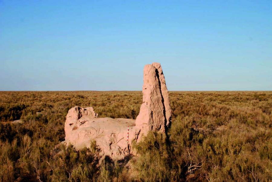
Jan-Kala hillfort has a three-part structure: citadel, shakhrestan and rabad. The citadel of the settlement is represented by several elements - the so-called palace surrounding its outer wall and the corner northeastern tower. The outer wall of the citadel, 1 m wide, surrounds the palace and forms the inner space of the citadel, 75×75 m. The central structure, conditionally called the palace, has the dimensions of 37×28 m. Finally, the octagonal tower with a diameter of 8 m is arranged in the north-eastern outer corner of the citadel. The outer wall is bordered by a moat, the width of which varies from 20 to 4 m. The lines of the citadel walls with a displacement of 15° are directed on the sides of the world. The entrance to the citadel is fixed in the center of the southern wall. Taking into account the form of the destruction of the wall and its preserved parts, it can be argued that the entrance had a width of about 5 m and on both sides was flanked by pylons protruding from the outside. From the north and south sides of the citadel, two channels with a width of 8 m and a depth of 3-5 m were laid along the east-west line.
Shahrestan of the hillfort is surrounded by a wall, the width of which reaches 5 m, including floats. The wall is severely damaged in all parts, although its height varies from 0.2 to 3 m. Shakhristan occupies an area of 236,370 m2. The directions of the walls of Shakhristan repeat the directions of the citadel walls. The walls of Shakhrestan are straight on the southern, western and eastern sides, and the shape as a whole resembles a rectangle. There are several large objects located on the territory of Shakhrestan. Among them, two can be interpreted as caravanserais. The rabad of the settlement is extensive. Its east-west line stretches for 1,800 m and north-south line for 1,500 m. Rabad development is not regular. There are significant fields and canals with numerous branches, cult buildings, residential estates, public facilities, small jerry buildings. Many buildings are fixed on the surface only on small hills and clusters of ceramics. Of the significant and quite well-preserved buildings on the rabad of the ancient settlement, we can highlight the suburban caravanserai, the central structure of which has a size of 30 x 25 m. The long axis of the building corresponds to the direction of the citadel axis. The caravanserai is located in the eastern part of the city, at a distance of more than half a kilometer from the outer walls of Shakhrestan.
In the south-western part of the settlement there is a country residence. Its functional purpose is the presence of a central structure 37×26 m, built by a combination of mud and burnt bricks, a garden-chorbak, which is a vast area - 48 000 m2, surrounded by a wall and has a local irrigation system, numerous second-order buildings. The whole territory of the country residence was surrounded by a wall 1 m wide, in the eastern part there was a powerful (3 m wide) entrance in the form of a peshtak portal. A similar walled but non-indoor garden and park area of 45,000 m2 was established in the northern part of the rabad. The walled area is adjoined by a 124×128 m square fringed by canals. Inside this area, there are two canals of firmer shape, the shape of which seems to be interpreted exclusively by the aesthetic orientation of the complex.
On the eastern side of the settlement, in the immediate vicinity of the outer wall of the Shakhrestan, there are ruins of the mosque (9.7 x 9.7 m) with a preserved mihrab wall and niches. The walls of the mosque are made of mud brick. The mosque, most likely, is memorial. This conclusion is prompted by the fact that the ruins of two mausoleums built of burnt bricks and decorated with glazed tiles with stamped ornaments of plant character are located nearby. On the southern side of the hillfort, on the territory of Rabad, there are ruins of another mosque built of burnt bricks. The size of the mosque is 12.3×7.3 m. This building can also be classified as a memorial building. The mosque has two halls. The outer one is gurkhana and the inner one is a mosque. Numerous estates, mausoleums and fields are scattered throughout the territory of the rabad.
Construction of the rabad of the hillfort was not dense. It was interspersed with open spaces, fields, different order channels. The irrigation system of the hillfort was based on a powerful canal from Zhanadarya. The line of the canal stretches in the western direction, but does not reach the boundaries of the settlement, divides into three or four large canals of the second order. One of them is broken up into several other third-order channels by a fan distributor, which are not inferior in size to the first and second order channels. One of the channels actually cuts through Shakhrestan in the center, dividing it into two parts - northern and southern. On the territory of Shakhrestan, a distributor was built on the same canal, which gives branching to three more canals, supplying water to the western part of the rabad and further discharging excess water. Small canals delivered water to defensive ditches, fields and gardens. Numerous structures with such a large number of canals were located in elevated areas.
Jan-Kala hillfort is a monument of history and culture of national importance. In 2012, it was included as a component of the serial transnational Silk Roads nomination in the preliminary list of UNESCO World Cultural Heritage Sites.