Information
- Location
- Karaganda Region, Shet District
- Period
- 1500 BCE – 1001 BCE
- Type
- Necropolis
- Kind
- Archaeological sites
Sources
- Қазақстанның киелі орындарының географиясы: Табиғат, археология, этнография және діни сәулет өнері нысандарының тізілімі / Жалпы редакциясын басқарған ҚР ҰҒА академигі Байтанаев Б.Ә. – Алматы: Ә.Х. Марғұлан атындағы Археология институты, 2017. – 1-шығарылым. – 904 б.
Description
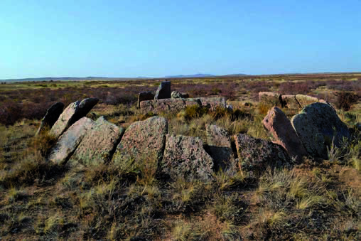
The monument is located in the intermountain valley surrounded by Tayatkan, Shunak, Ushkyzyl mountains (Shet district, Karagandy region). Nearby are two springs, full-flowing all year round. At present, the eastern side of the monument is covered by a railway. There is Kiyik station 17 km to the north-east and Moiynty station 40 km to the south-east. The monument dates back to the second half of the II millennium BC. One of the largest burial grounds of the Bronze Age of Central Kazakhstan. There are more than 150 different burial sites at the Belasar burial ground, which have been abandoned for more than 1,500 years. It is obvious that the area was distinguished by favorable natural conditions for the population in the Bronze Age. The valleys of the Moynak, Karatal, Shazhagai and Atasu rivers are known for their rich pastures of Akdala and Shybyndy, which contributed to intensive cattle breeding. In the Koskuduk, Mynkainar, Shalkiya, Bolattau mountains, ancient non-ferrous metal mines were discovered, and on the Zhideli River - flint deposits. The Belasar tract in its convenient location was a sacred place for the inhabitants of the developed and late Bronze Age. In 1957 and 1968 under the leadership of A. Kh. Margulan four fences and one barrow-fence were explored here. Judging by the grandeur, power and complexity of the funeral constructions, the burial structures belonged to the elite of the ancient society. The findings in the form of clay vessels intended for sacrificial food and decorated with characteristic ornamental compositions, unique bronze bracelets and plaques testify to the high social status of the owners. Apparently, at the end of the Bronze Age, part of the population of the region migrated to the lower reaches of the Syr Darya and, mixing with the local population, founded the burial ground Tagisken with the monumental raw mausoleums, revered for a long time by the inhabitants of the Syr Darya in the Bronze Age, and then in the early Iron Age. The burial ground of Belasar is located on the ancient caravan track connecting the steppes of Saryarka with the south. Favorable natural conditions were one of the reasons for the active development of the territory and its sacralization: here were the main shrines - the graves of ancestors. The monument is an object of historical and cultural heritage. The monument is a tourist attraction.